Advertisement
Published: March 21st 2009

 MS275320
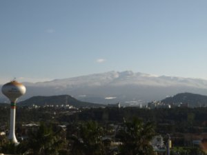
View of Jeju from the airport.Here are the long overdue pictures from our trip to Jeju Island in January.
After the most terrifying flight of my life (which consisted of 3 attempts to land in a snowstorm, and an uncountable number of filled barf bags) we finally landed in Jeju-si, the capital of Jeju. After we rented our Matiz (a cute teeny Korean car) we spent the first day driving around Jeju-si. We visited Samseonghyeol, the birthplace of the people of Jeju. Samseonghyeol consists of 3 holes in the ground which legend says, 3 brothers crawled out of and founded the Tamna kingdom. We learned all about Jeju's history from an interesting anime film with no English subtitles.
After Samseonghyeol, we headed to Jeju Loveland, an erotic sculpture park created by artists from Hongik University in Seoul. Interestingly enough, it is not mentioned in Lonely Planet. After Loveland, we braved the snowstorm (after 2 closed highways) to visit Sangumburi crater, then continued on to Seongsan so we could hike Seongsan Ilchulbong crater for sunset. Unfortunately, the snowstorm continued through the next day so the sunset clouded over, but thanks to some fancy settings on my camera we were able to get some good shots.

 DSC01707
Jeff and I in our rental Matiz.Both these craters are dormant volcanoes which you can hike up.
After Seongsan Ilchulbong we drove to the Manjanggul lave tube caves, which are supposedly the world's longest system of lava tube caves. The caves are 13.4 km long, although only a few kilometers are open to tourists. We then headed down to the south coast to see Jeongbang and Cheonjiyeon waterfalls as well as Jungmun beach. We also stopped at the Jungmun Daepo Jusangjeolidae rocks which are Hexagonal rock columns formed as a result of molten lava flowing straight into the sea. We spent the night in the Worldcup Jjimjilbang, which is one of the more elaborate saunas we have been to.
The third day was spent hiking up Hallsan, the tallest mountain in Korea (1950m). We took the Seongpanak Trail, which was the only trail open in the winter. The trail was so snowy and packed down we had to buy crampon type spikes for our hiking boots. The hike was incredibly fun even though we weren't able to make it to the top of the crater due to the weather (or should I say season).
Once we finally made it back down the mountain

 MS244537
Samseonghyeol Shrine, the supposed birth place of the people of Jeju. we drove back to Jeju-si and along the Coastal Road to take in the coastal views. A part of this road is known as Cafe Street which it quite literally filled with dozens of cute cafes, so of course we stopped in and enjoyed some java. We decided to spend the night near Gwakji beach which was a beautiful area, so after visting a few beaches nearby we stayed at a minbak (a guesthouse).
On our final day we went to Hallim Park, a park which had everything (lava tubes, folk village, bonsai garden, botanical garden, and the list goes on). We spent the morning there before heading back to Jeju-si where we stopped in at the Jeju Folklore & Natural History Museum. Our flight out of Jeju, was much smoother than the flight in although I was so nervous it seemed just as bad. I would really like to head back to Jeju to experience the beaches in the summer and maybe also to hike to the crater at Hallasan, but maybe next time I'll look into the ferry.
Advertisement
Tot: 0.094s; Tpl: 0.012s; cc: 10; qc: 50; dbt: 0.0477s; 1; m:domysql w:travelblog (10.17.0.13); sld: 1;
; mem: 1.2mb

 MS275320
 DSC01707
 MS244537


Momma Stobbe
non-member comment
Thanks for posting!!
Great photos! Okay, those sculptures were a little over the top - some of them almost Dadaist. Those lava tubes looked fantastic - much larger than the ones in Sicily. And the lava columns on the beaches looked really interesting. Looks like a great place to go back to in the summer.