Advertisement

 Mayasan
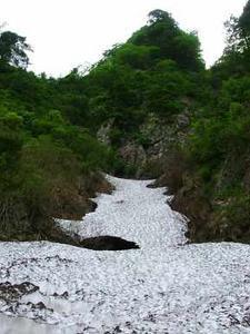
View up snow field on MayasanThis was looking like it would be a weekend of failures. Firstly we had been planning to go to Fuji as a large team ..... But we could not find crampons to fit onto Balazs' titanic shoes. Secondly I decided to go to Fuji by train alone and meet Gary at Fuji station ...... But the last train from Tokyo to Fuji was fully booked by drunk people.
Finally I called Philippe who said he would be around the following morning at 7-00am with a surprise adventure for me. OK this sounded promising!
As morning came it was apparent that we had rain and gravity was high making it difficult for us to get out of bed. Eventually we got it together to leave Sendai at about 10-00am after a brief stop in Lawsons. In the Car Philippe explained that the plan was to firstly climb Maya-san from the East side then descend and go by car to Hayama and climb up that in the evening and bivvy out somewhere there. Next day we would continue the full circular traverse of Hayama and then quickly nip off to Gassan to get to the top with the help of the lift

 Snow field
Another view up snow fieldfor a large part of the ascent. ...... Philippe is usually a little over ambitious!!
video of the cliff path  Access to the East side:
National Route 112 runs parallel to the Yamagata expressway, but to save time you can use the expressway until the end of that section at Gas-san IC (Yamagata expressway starts again further North). From Gassan IC use the main national Route 112 (from Yamagata to Sakae). Head North West for about 20-30kn (road winds so hard to judge) then turn left to use the Route 44 (regional) for few kilometers and this road will turn into Route 349 without you noticing it by any curve or direction change ..... it just kind of blends in!
Keep on going on route 349 and you will arrive at the Dam. this is too far.
You need to turn right just before a sign of a big trout and drive for a few km down a small road through a small village passing injured snakes on the way.
This road then merges to a dirt track which you drive to the end of until the parking area. The parking area is new and may not be the

 Mayasan east
East face of Mayasansame as the position of the end of the road on your map (If you have one).
Park the car and prepare for the trek.
There is a warning sign in the car part to inform you of the climbing period and the dangers ahead. Ignore It!! .................. At you peril!!!
For our East Side adventure read on below

Anyway by the time we got to the Trail start on the east side of Mayasan it was already 12-40 in the afternoon so I suggested to skip Hayama and just get to the top of Maya-san then down to the hut on the other side. A sign at the beginning of the hike was placed to inform that the safe climbing season for this mountain was from the beginning of June until the middle of October. Maya-san is in Yamagata close to the Japan Sea ........... So it is a hostile place in winter despite it being a mere 1020m in height. It was already June so we assumed that we would not need special equipment. All the same we took our axes, I packed a small 20m dynamic rope and Philippe packed a few slings

 Mud
Mud
Mud climbing a gulleyand screw-gate carabiners.
So off we trotted only to be thwarted in our tracks after 10m by an unsignposted fork in the path, with the left branch going over a fiercely flowing river and the right branch accessing a ridge. After about 30 minutes of reconnaissance, map consultation and Sansai gatherer consultation (many Japanese love to pick edible mountain vegetation or Sansai ................. but unfortunately they know squat about mountain trails) we took the path to the right, partly because the river was difficult to cross because of the amount of melt water.
Soon we were ascending a very thin tree lined ridge up towards our goal, with long drops on either side. Despite this the path was not intimidating at this point. Up and up we went from time to time glimpsing views of the target ahead through the trees, a steep tree covered cliff with some bare rock and cascade flowing down the middle. Philippe commented that he was having some doubt about the climb ..... As usual I quoted Vitally ... "Mountain like beautiful lady - Always more intimidating from distance" and I pointed out that the path probably did not go up the cliff by the waterfall.
Up and Up until about 600m where we met a descending hiker. We stopped and asked him about the route ahead. He said that he had taken the direct route up the ridge that we were currently on, but had been stopped by a section of path where a mud slide had left a bare section with no security, little for hands and feet and a big drop below. This settled our choices, we would take the alternative path to the right, when it appeared a little way ahead of us.
We arrived at the poorly marked path (the signs were still in a sack waiting to be put up) and began to descend what eventually turned out to also be the remains of a mud slide, but it was marked with red tape so we continued down to the snow river in the gully below. Once on the snow river we ascended a little to try and locate the path onto the adjacent ridge. Philippe was successful, but I had ascended too high and was left climbing up a muddy gully using my ax blade to thwack into the mud to keep me in place in the parts where the bushes were absent. At this point I was glad of the bush climbing training we had obtained in our ascent of Mogami-Kago. Eventually I reached Philippe on a nice looking path and we continued up the ridge towards what was looking increasingly more like a steep cliff ahead of us. Un-deterred we ascended up mud and rock, from time to time seeing chains bundled up on trees. These were obviously intended to be laid at some point to offer security for hikers using the path, but as yet they were still bundled up.
We got out of the trees and found ourselves climbing a very narrow path with a large drop below us. The only evidence that we were still on track were the bundled chains we saw from time to time on some flimsy looking bushes. After a few exposed steps over void and an ascent upwards to steeper ground we found ourselves at the cascade. Our choices here were few. There was no indication of the next direction. Traverse the cascade (with the snow gully some 40m+ directly below us), straight up the cliff to the side of the cascade, or up through the muddy bushes directly above us. No bundled chains in evidence to beckon us on. I put on the 20m rope tied to a sling round my waist with the intention of traversing the cascade. With foreshortening the top of the cascade looked close to the top of something so may be a look on the other side would get us out of Dodge. However good judgment prevailed and, with it being 4-00pm already and knowing that we had only reached about 700m with 320m still above us I decided to use the rope to make a safe retreat. It was not obvious at all if going on would get us out of or deeper into trouble. Further I was being eaten alive by black flies (I am still scratching as I write).
So we began the descent, slinging saplings to belay for protection. 20m is a bit short, but within half an hour we were back in the snow river in the gully. I was of a mind to come back the next day with a longer rope, a harness and a few more slings to get to the top via this route, but Philippe was unconvinced. We reached a compromise to get to the top via the easier route which can be accessed from the West. So we drove all the way round to the West side of Mayasan.
West Side Story Access to the West side:
National Route 112 runs parallel to the Yamagata expressway, but to save time you can use the expressway until the end of that section at Gas-san IC (Yamagata expressway starts again further North). From there use the main national Route 112 (from Yamagata to Sakae). You can keep on Route 112 until after Nishiaraya where you should take a left turn onto Route 349 heading North for about 8 km until you can turn left onto Route 345. No one is pretending that this will be easy!!!

When we arrived at the West side we intended to sleep in the car park at the beginning of the West access path. Philippe was insistent that he would bivvy in the woods using his tarp for cover. I was equally insistent that I would not move from the car as I'd had my fill of bugs, what with the black fly on the cliff. Eventually I was persuaded to join Philippe to drink beer outside with the moths dive bombing us because of the camping lamp, covering our cups with our hands. When the beer and wine was gone I returned to the car to sleep. Next morning I awoke at about 7-00am to find that it was raining hard and Philippe had moved closer to the car and abandoned his tarp. He had been inundated with bugs that night and some rodent had eaten into his food bag. The final straw was a mukade (centipede) that had attached itself to his bivvy bag. He is now re-thinking his bivvy strategy.
We quickly prepared for the hike in double quick time, eventually managing to depart the car park by 8-30am --- well thats fast for us.!! When Philippe had asked me which path we should take I sternly replied "the easiest one!" I wanted to get this mountain climbed and then get back to the car and home.
The start of the hike was very pleasant, despite the rain, going through a gorge above a river with the remains of many avalanches piled up in places below the steeper treeless gullies. Eventually after a gentle ascent we reached a fork giving us the choice between the Beteran (Veterans) course or the beginners course ....... despite my earlier insistence I had too much testosterone to accept going on the beginners course so we took the veterans path to the left.
This path went above a river with some small slippery steps in parts, but it was not so bad. We eventually arrived at a waterfall with a ladder chained to the side, which we had to ascend to reach the steep muddy narrow ridge above.
This ridge became slightly more gentle but went on and on and on in high humidity, making our eyes sting with sweat, until finally the trees cleared and we reached the ridge narrow leading to the summit which was visible in the fog about 30m to our right. Many people (10) were picnicking there. We arrived at the top at 10-15am, the ascent taking us 2 hrs 5 mins.
On the top we passed some short time, luckily there was a map to point out which mountain was which in the distance through the fog, otherwise we would not have been able to appreciate the potential view before us through the white clouds which we were now fully in the middle of.


The view from the top
The picnickers on the top fed us some dried kaki (is it presumptuous to hike up a hill with a knife, fork, hashi and a plate but with no food of your own?).
At 11-20am, after making a few videos, we began the descent down the beginners course which continued along the ridge to the west.
We passed a shrine and a line Jiso meeting a couple of fast hikers along the way (later we re-met them on the way down). The hike was moderately easy with just a few slightly tricky places to overcome, where mudslides had altered the path.
Eventually we arrived at the hut where we were greeted by Rick and Mico Rettig and their friends. They were taking a rest at the hut whilst their other friends continued to the top (the two fast hikers we had met at the shrine before). Eventually we were all drinking beer and coffee in the hut fortifying ourselves for the descent. From the hut there were again two choices: Easy to the left or veterans to the right.
We chose the course to the left rather than the veterans course. We passed by Rick, Mico and Co. who were picking their way down a slippy section and returned to the valley floor down a moderate ridge arriving back at the car at 13-15.
After we had changed into some dry cloths the Rettig party arrived and invited us for Soba and an Onsen ............. the kind of offer that we never refuse. So for the next couple of hours we eat, drunk beer and soaked in hot water.

The trek map with GPS coordinates superimposed.
You can get more details on this hike at:
Kamp-High
Advertisement
Tot: 0.073s; Tpl: 0.01s; cc: 9; qc: 48; dbt: 0.0308s; 1; m:domysql w:travelblog (10.17.0.13); sld: 1;
; mem: 1.2mb


