Advertisement
Published: July 21st 2013

 Xinjiang Tian Shan
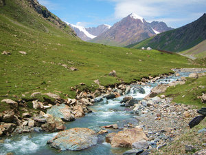
I am going to the topI woke up at 6am but as I opened the tent and realized the sun was still behind the mountains, I decided to stay in bed a bit longer… I really wanted to take many pictures of the gorge, the blue river running down below and the green mountains. It wasn’t my intention to just cycle through it very fast. Time was not an issue. This year ahead of me, I DO HAVE TIME! So eventually after eating breakfast and packing I was about ready at 10am… The sun had just flipped above the peaks and the colors of the gorge already looked stunning (my favorite English word!).
I didn’t really have time to warm up, I was already going up a steep hill. I met some construction workers a bit farther down and they told me I would be going up for at least 40km. Usually I ride at an average speed of 20km/hour but it was so steep and the road was so bumpy that I probably only rode at 10km/hour (once again, I have no bike computer or GPS, so I calculate distances according to road signs and maps, and I can usually tell how fast I’m
going from experience). As I said before the view was so great that I stopped every 5 or 10 minutes to take pictures. I guess this didn’t help my average speed of the day. I remember thinking that it was the hardest leg I had done since the beginning of my journey. The road kept on going up without any respite. Around 12 o’clock it got hot in spite of the altitude (above 3000m) and I regretted starting the day so late…
I met a Chinese motorcyclist who knew the road well and he told me that once I went over the mountain pass at 4200m of altitude, the road would then be going downhill for more than 100km all the way to Kuerle. “I’m sorry, did you say 4200m of altitude?!!!” I was excited every time I saw a white peak of snow but when I told the construction workers about the snow, they told me that there would be a lot more of it a few kilometers up the road. Really? Cool… I guess… And the road went up and up and up. I told myself I should take pictures as often as possible and this was
a good excuse to take many short breaks. Around 3pm I got to a group of yurts at the foot of the mountain pass. The mountains behind looked entirely grey and white: covered in snow and ice and dark rocks. There were no more trees, no more grass. Outside the yurts, Chinese Kazaks were roasting skewered lamb. It was soooo tasty! I was so hungry! 2 tourists who had driven from Urumuqi shared some Muslim bread with me and some of their tea. The husband told me I would never make it up the mountain because the road was too bad. The road was all dirt and gravel but it looked okay to me (from the foot of the mountain). I could see the laces going up all the way, just like when the cyclists get to the Alps at the Tour de France. Except they don’t carry 60kilos of stuff and the French roads are always paved. I took a nice little break, filled up on water (boiled water from the river), gathered my energy and went for it. The Kazaks told me it was about 10km to the top.
I am now laughing about the whole thing

 banana smile!!
... and yes, I had just eaten some Oreos!because, looking back at it, I know I made it and it is one of the best memories from my journey so far but… it was steeeeeeeeeep! So Steep! It was so difficult! I went slowly, took some breaks to breathe and take pictures. Halfway there the sky got very dark. A car passed by and a lady screamed at me to hurry up because snow was coming. Haha! Snow? Come on… I tried to focus because the road was so bumpy and there were stones everywhere. I tried to avoid the holes and the sand. Somewhere near the top, a car coming the other way full of Chinese tourists stopped and I asked them how much longer it was to the very top. They answered 300 meters. I asked again and they confirmed there were only 300 meters left. Skeptical but relieved I pushed hard on the pedals but 500 meters farther, the top was still not to be seen. Come on people! Did they say 30 minutes? No, they said 300 meters! #$%^@#!!!! 2 laces up, some guys were taking pictures and they started taking photos of me struggling up. When I stopped by their car to breathe,
the Dad offered me a Red Bull and it felt so great! Thank you, Sir! Thank you so much! They told me I had to go up another 3 laces before getting to the top. And then… it started snowing! My hands were numb and my chest was getting colder. I was sweating though. I decided to put on my jacket and keep going. 2 hours ago, I was getting sunburned and now it was snowing on me. At one point the road was so bad and steep that I had to walk and push my bike up the hill… I didn’t want to but I had to. It was too hard. My quads were on fire. The scenery was so unusual. The experience was unique. I was in the middle of nowhere in Xinjiang Province, riding a fully loaded bike, by myself, admiring the snowy peaks on a road that only few people have travelled, going through one of the toughest physical experiences of my entire life; I was listening to Elvis and thinking of Becky, feeling all sentimental… I got overwhelmed by too many feelings of pain, happiness (what an experience!), anger (at the weather), sadness (being alone),
pride… I cried!
I reached the top and took pictures of the sign that indicated I had climbed up to 4280m. I did feel pretty proud. The previous morning I had been in Urumuqi at an altitude of about 800m. At the top the wind got very strong and cold. The motorcyclist was right: it looked like it was going downhill all the way and for a long way afterwards. I had to dress up to face the wind and the snow. I opened my bags to look for my winter gloves. I took off my shorts to put on long cycling pants and I added an extra shirt. The thing is I didn’t remember in which pannier my winter clothes were and it took me a while to find them. You need to imagine me on top of the mountain in my underwear looking for pants and gloves (that of course were at the bottom of the last pannier I opened) with snow falling on me. It snowed for 40 minutes. I was very careful on the way down with all the stones (2 days later I would realize I had broken a spoke on my front wheel)
and then it rained a little and suddenly, the sun was back and the grasslands greeted me with a rainbow.
I went downhill for 2 hours (so much fun in spite of all the bumps!) and found a gorgeous place to camp by a river. I set up camp in between big rocks surrounded by wild flowers. It was magical! I thought I was far enough from the road not to be seen but this is China, and in China there are people everywhere! An hour later a Kazak family paid me a visit. I talked to the son for 2 hours. His Mandarin was pretty clear and he told me he was planning on going to Urumuqi to study English. I recommended him a few books. He said he also loved hip hop and showed me some cool moves in the grass. At night I woke up around 3am because I heard some noise. I stepped out but didn’t see anything except… the most beautiful starry night I have seen in 7 years in China! Waking up to the sound of water cascading is an amazing feeling. Opening the tent and seeing bright yellow and purple flowers, blue
sky above… What a blessing!
The road to Kuerle was downhill the whole way. I think there were at least 80km of dirt road. I was still dazzled by the mountains and the clear water from the river I followed. I had lunch with my feet in the water. It looked so pure and there was nobody around. Unfortunately I quickly hit the paved road again and everything got uglier: industries, construction, police stops, trucks, pollution, litter… 50km away from Kuerle it started raining heavily for 2 minutes and big threatening clouds were on their way. Becky warned me that hotels for foreigners in Kuerle would be expensive so I decided to camp one more night before getting to the city. I found a place to camp at the entrance of a small town, in a small tree plantation and spent maybe 2 hours with a 16-year old Uyghur shepherd. He made me listen to some English songs so that I could tell him about the meaning of the lyrics. Kuerle is surrounded by barren hills on one side and grey rocky desert on the other. I did miss the trees and the mountains.
Road 216 was incredible.
It was a tough ride but that’s part of the adventure. This is exactly what I expected to go through when I dreamed of this journey on my bike. Something tells me I will be back here someday soon. Cycling with Becky? With my Dad? But I won’t cover the 400km in 3 days like I did this time; I will take my time and will do a bit of hiking if possible. I hope you enjoy the pics! Cheers!
Advertisement
Tot: 0.061s; Tpl: 0.014s; cc: 11; qc: 34; dbt: 0.0328s; 1; m:domysql w:travelblog (10.17.0.13); sld: 1;
; mem: 1.2mb


ingnova
Ingrida
Wonderful
at the beginning of reading i was thinking, i want to go there as Tian Shan for long now in my consideration, just not on China side. Thanks, for adding that detail of people everywhere even what it seems desolated place. So it remains the same, so thank you for sharing China side. It so much nicer to read blogs than dry official information. Your range of emotions reminded me of stories of altitude sickness, which must be mingled with exhaustion. I congratulate you on such experiences with the world and within yourself :)