Advertisement
Published: August 15th 2009

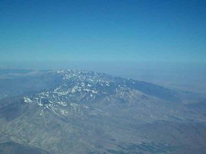
 Afghan Mountains
Just to the west of Kabul. Topping 16,000+ feet.It is difficult to say that there is a typical day of flying here in Afghanistan. But it is not as though it is absolute chaos, either.
On Thursday, Luc and I were to fly to four places: first Bamyan, then Herat, then Kanadahar, and back to Kabul. However, things being the way there are here, our routing was destined to change. Remember, we fly passengers for the UN. The first stop was to be a quick little hop over the mountains into thin valley oasis of Bamyan. Eight passengers...forty five minute flight. Instead (due to a departure delay and other circumstances), we flew to Herat, to Kandahar, then to Bamyan. Those eight passengers were granted a four hour tour over the desert mountains of western Afghanistan instead of their initial hilltop hop. Nevertheless, they are aware of the
unique circumstances of airtravel in a war ravaged country a week before an election and accepted it.
To see the country from 20,000 feet is something else. At this time of year there is little rain and the khaki dust spreads itself across the landscape. But don't think of it as the Sahara...almost every valley is granted a year-long supply
of water from the eastern mountain glaciers. And where there is water, there is green, and where there is green, there is life. Villages of generations exist miles from the major centers with not much more than a goat trail to link them.
As we travel west, to Herat and Kandahar, the mountains flatten to hills and ridges that have little use but block to the winds from stripping sand, vegetation, and human from the face of this earth. Averaging more then 40 degrees Celsius during the daytime, our half hour stops in Herat and Kandahar are long enough for me.
But the trip back, stopping in Bamyan is definitely worth the sharp sun and the soggy shirt. From the west, we drop down between two impressive ridges (the one to the north is 14,000+ feet and the one to the south is 16,000+ feet). Keeping the rocks just off of our right wing, we skid down the side of the mountain until the deep green of the Bamyan valley makes a right, then a left, and then another right. There, just before that turn, is the plateaued gravel strip we have the privilege to place our aircraft

 Bamyan Approach
Airport elevation - 8,700'on. It is one of the most beautiful approaches I have ever seen (as a pilot, this beauty also comes from the challenge of the approach).
Kabul has it's own beauty and it's own challenges. Helicopters, heavy transports, and the semicircular ring of mountains that surround the city mix the radio frequencies and foreign accents into a cauldron of nonsense most days, but if it was easy...it wouldn't be Afghanistan.
Cheers,
Jay
Advertisement
Tot: 0.074s; Tpl: 0.01s; cc: 5; qc: 44; dbt: 0.0339s; 1; m:domysql w:travelblog (10.17.0.13); sld: 1;
; mem: 1.1mb

 Afghan Mountains
 Bamyan Approach
Mom
non-member comment
A Day On
Great pictures. The mountain valleys and villages remind me of Papua New Guinea. I wonder how they get an election accomplished with the inaccessible nature of some of the population. Mom