Advertisement
Published: September 23rd 2009

 Photo 1
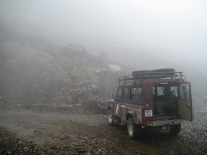
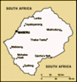
The infamous Sani PassLeaving J-Bay by coach (16 hours, overnight, crap!), I make a detour to Durban to fix my wide angle lens, which I dropped onto tarmac trying to get a photo of a whale's tail at Mossel Bay... all v. annoying! I decide to hire a car to travel up to the Drakensbergs and then east through KwaZulu-Natal and Swaziland to Kruger Park, so I collect Guppy (named in accordance with the Chris and Tracey Parkin car naming rules) from the airport and head north towards Pietermaritzburg and on to Underberg. I'm heading here to travel over the mountains and into Lesotho, a small country totally surrounded by South Africa.
I arrive at Sani Lodge, just north of Underberg, in the late afternoon, just as the setting sun is spreading an orange wash over the Southern Drakensbergs, Next morning, however, a thick mist has enveloped the lodge and a slow drizzle (you know, that fine rain that soaks you through) is falling. Just the weather for driving up the Sani Pass - a steep mountain track prone to ice and landslides. Sani Pass is the only route connecting the Southern Berg with the mountain kingdom of Lesotho, and has been used

 Photo 17
A typical Lesotho villagefor decades as a key trading route - first on donkeys, and now by 4x4s along a rough, un-metalled track. There are just 5 of us making the trip into Lesotho today - myself, Janet, Steven, Stefan and Kim, plus our driver and guide Matthew.
In the lower parts of the pass (or at least what we can see of them through the mist), we pass an abandoned trading post as we head towards the South Africa border. In the days before the road, the post was used by the Basotho people of Lesotho to trade their wool and milk for commodities from South Africa, providing an overnight stop before their arduous trek back across the mountains. Crossing the border, we climb through an unusual landscape... patches of dry orange grass sit next to large burnt areas, filled with fresh green shoots. Matthew explains that controlled fires are started so as to encourage new growth, a process that occurred naturally throughout the region before man-made interference. Some of the indigenous plants, such as the protea, even need fire to reproduce.
As we reach Sani Top, the mist magically lifts and we arrive at the Lesotho border control amidst

 Photo 13
We're being followed...glorious sunshine and a clear sky - the Sani Pass below us is shrouded in cloud. The part of Lesotho we've entered is remote and sparsely populated, although the presence of the border crossing still attracts traders, and there are signs of tourism development starting to creep in. We drive past the nearby village and over the second highest pass in Lesotho, stopping for lunch and taking a short hike to a nearby ridge to see southern Africa's highest point - Thabana Ntlenyana, at 3,482m. After the walk, we head back to the village, doing our best along the way to spot the solitary young shepherds hidden in the barren local bush. All Basotho boys are sent out to look after the flocks of sheep for a year or so when they reach the ripe age of 12 or 13... in Lesotho this is a rite of passage, and their return from the shepherding is seen as a coming of age.
We stop briefly at a nearby hut, where a white flag is flying... in Lesotho, people advertise goods by erecting flags outside their homes. White for beer, red for meat and green for vegetables. There is also apparently

 Photo 14
The locals teach our guide a new dancea yellow for pineapple beer, but this is quite rare! Clustered in the cosy, dark hut, we share a cup of beer (only about 4% proof, but white with floaty bits, and tasting a bit like cider) and a chunk of warm bread, straight from the cow-dung oven. We say goodbye to our hosts with the traditional three-stage handshake, which means Peace, Rain, Prosperity - a sign of how important water remains to these agricultural people. Outside, we're serenaded by a Basotho man wrapped in his customary blanket, strumming on a tin-can guitar... we watch a small troupe of local boys dance and sing along as we head back towards Sani Top. Our last stop before tackling the pass is the Sani Top Chalet - purportedly Africa's highest pub (although any local hut which decides to erect a white flag could easily trump that claim). We down a glass of mulled wine before jumping back into the cold Land Rover to repeat our African massage back to Sani Lodge.
From Sani Lodge, I drive north to Bergville, to the Northern Drakensberg. Wanting to spend more time in Lesotho, I decide to join a second tour heading into the less
well visited north-east corner of the country, reached via the Monantsa border crossing. We set off from the Berg with our guide, Zi, driving first through the sprawling settlement of Qwa Qwa in the Free State. Although not shown on my road map, Qwa Qwa (the Q is pronounced as a click) is home to nearly a million people... some living in the old township, but most in informal settlements, tacked onto the sides. It sprawls across the foothills as far as the eye can see, and is beginning to encroach on the Drakensbergs themselves. Zi tells us that Qwa Qwa is now an attractive place to live, in contrast to its founding under apartheid for relocated 'coloureds'. However, no white people live here, even though they own most of the businesses.
The main road into Lesotho through the Monantsa pass is being ashphalted as we enter, and there are similar plans for Sani Pass. We drive to a local school, and immediately the landscape is surprisingly different to that at Sani... there's a lot of greenery, and the peach trees are in full bloom, adding pink blossom to the mix. After visiting the school, which is partly sponsored
by the lodge I'm staying at, we hike up into the hills to enjoy the view and admire some fading San rock paintings. Despite attempts to protect them, these particular paintings are disappearing fast, and are unlikely to be here in 5 years' time. They show an Eland and San bushmen, including a warning not to stray too far to the east... a warning to stay away from the Zulus. We learn about Basotho culture from Zi, and the history of Lesotho's independence (first against King Shaka of the Zulus, then the Dutch and finally as a British Protectorate). We descend into the village for more beer (completing a short pub-crawl by linking the white flags), then visit another hut for sweet bread, maize and spinach.
Before leaving, a local elder, whose hut played the role of a pub for the afternoon, teaches Zi the Sesotho word for kneel - kgumama, which also means prayer. She breaks into song, and begins to dance around. The men inside the pub hear, and before long she's joined by a small group of backing dancers, all waving their walking sticks and swishing their blankets. We return to our car after an unsuccessful
hunt for the local medicine man, then return back through the Monantsa Pass to South Africa.
Advertisement
Tot: 0.078s; Tpl: 0.012s; cc: 11; qc: 28; dbt: 0.0424s; 1; m:domysql w:travelblog (10.17.0.13); sld: 1;
; mem: 1.1mb


