Advertisement
Published: September 8th 2008

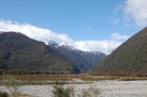
 Clouds
just liked the clouds and mountainsText for travelblog, Glaciers Sept 6, 2008
Last Friday we took the 4.5 hour Tranz-Alpine train journey from the east coast of the South Island to the west coast, arriving in Greymouth, an aptly named town, except upon our arrival. We noted that the skies were actually gray and cloudy when we left Christchurch, and as we passed through the tunnel at Arthur’s Pass that took us through the Southern Alps, the sky became bluer and the weather cleared. Apparently, it is common for the weather to be different on either side of the mountains. There is wonderful scenery from the train; especially the deep gorges that we passed over on the east side of the tunnel.
Upon arriving on the west coast, we had a rented car waiting for us, and we immediately set out for the Glaciers, about 2 hours to the south of Greymouth. There are a few towns on the coast road, but we planned to head directly south except for stopping for a quick picnic, intending to explore a bit more of the area on our way back north. One place we did stop, lured by the giant sandfly sculpture hanging in the front
of the building, was a place called "Bushman's Cafe and Museum", devoted to the history of the west coast and explaining why New Zealanders hate the possum, a cute furry animal which was imported to the island years ago to start a fur industry, but which has now overrun the forests and is eating the rainforest canopy.
The first glacier town is Franz Josef, named after the glacier. We had reservations for the “full day hike” on Saturday. Franz Josef is a cute little town, and we stayed at Montrose Backpackers. We had a pizza dinner and stopped by the glacier guides office, where we were told what to wear and bring on the hike(lunch, layers of clothes, water).
Early Saturday, we were dressed in our long underwear with shorts over them, and about 4 layers on top, per instructions. We looked ridiculous. When we arrived at the Guides, they gave us snowpants, rain jackets, boots, wool socks and gloves. They ask you not to wear jeans because if they get wet under the snow pants, they take too long to dry. They bused us to the trailhead, and then there was a 45 min BRISK
walk to the base of the glacier over a rocky trail. When we got close enough, we learned to attach crampons to our boots and were instructed to “walk wide” like John Wayne, and stomp our feet so the crampons will grip the ice. The guides cut steps into the ice so we could climb up, but some of the steps were quite high, and for short people such as myself, it was pretty tough to climb them while wearing the heavy footwear. When we finally ascended the glacier, the views were lovely, and there were lots of waterfalls to see, and we walked through some interestng formations such as ice caves, tunnels, and through some deep cracks in the ice (which requires descending into a narrow canyon and then ascending again). Somehow there are streams running through the glacier, as well as sometimes deep pools of water.(on ice? how is that possible?) Overall, it was pretty cool. However, it was quite exhausting to me, and since the others in our group were literally half our age, as they were scampering around the ice, I finally learned the meaning of “tramping,” as the Kiwis call a long walk. At one
point, while descending some treacherous stairs, I slipped and fell, not injuring myself, but one booted foot fell into some icy water and immediately soaked completely through.(later I realized my boots had holes in them!) How Randy was able to navigate the trail and still take pictures is completely beyond me! I felt lucky to make it through to the end and remain in one piece!! For those of you have read Randy's log about him twisting his body through a narrow ice cave entitled, “cave of no return”; I did NOT do that!!! Did I mention that I had a heavy backpack on for the whole day as well? By the time we came off the glacier and made our way down, I was completely spent. I knew that the next day my legs were not going to want to work!! We were very lucky that the day was sunny and not too cold, because I can’t even imagine doing this in the cold and wet. They actually do run these tours year round, so it must be wetter from glacier melt in the summer. OK, note to anyone else my age; take the ¾ day tour, designed to
be “more leisurely.” It covers less ground, but I think the pace is a bit slower.
We met a very sweet premed student from Germany at the hostel who went on the same glacier hike. Veepka is traveling around NZ all on her own for several months. We invited her to have dinner with us at the hostel, and Randy made a nice chicken and rice dish. Then we dragged ourselves off to bed to rest our aching legs.
The following morning we rose with some difficulty, and drove about 30 minutes south to the Fox Glacier. The surrounding topography is quite different, so it is worth seeing. Note to self: Should have taken the hike at Fox; it’s much easier to get close to the base of the glacier. We took a nice manicured path to the glacier and also took a nice FLAT walk around Lake Matheson, which is a very pretty trail. The lake has several viewpoints where the snowcapped mountains are reflected on the surface of the water. We had lunch in town (the town is one street, and 3 of the businesses are helicopter tour services!) but decided to return to
Franz Josef for the night, and booked into the Glow-worm cottages, which had a SPA. Boy, did that feel good on our aching muscles. There is a short trail in Franz Josef that leads to the glowworms, and we visited the first night and did see them. They are like little points of light on the trees when you switch off your flashlight. It is a little scary to be in the woods in the dark!!
The next day the weather started to change and rain moved in. The forecasters used that disturbing term again, “weather bomb.” However, the west coast is known for a lot of rain, as well as for sandflies, which sound like the greenhead flies we know at Barnegat Bay, but they fortunately did not visit us!! We made a few stops on the way north to Greymouth, most notably at a town called “Hokitika” which is known for crafts. Strangely, there are no good harbors for boats on the west coast (separated from Australia by a 1400 mile stretch over the Tasman Sea). Hokitika had a treacherous harbor, and there is a memorial at the waterfront to all the ships that were grounded

 Dressed to hike the glacier!
The crampons are in the fanny packor wrecked in their attempts to land there. Greymouth has just a small harbor, mostly for fishing boats, and they actually transport their main export, coal, all the way to the east coast by train for eventual delivery to Asia. The area around the glaciers is a temperate rainforest, and there are giant fernlike plants; it is very lush and green, but in a different way than the east coast, where we are based.
There were two really good things about Greymouth; the most fantastic hostel we have stayed at yet, and the Pancake rocks. For the 2 days we were based there, the weather was quite poor, so we were not outside very much. The Global Traveller’s hostel was quite luxurious. For our $50 NZ ($35 US) we had a lovely double room which was decorated with lots of artistic decorations from the owners’ travels. The main common room was likewise decorated with many items from around the world, mostly Asia and Africa, and had a cozy wood stove, soothing music on the stereo and comfy furniture. Even the bathrooms were pretty high end. Not a bad place to spend 2 days!! We met a local man,

 Franz Josef Glacier
Approaching the glacierJim, and spoke with him for several hours about life in New Zealand. We also visited the Pancake Rocks, which are formations of layered limestone just north of Greymouth. There is a great (short!)walking trail from the road to the area of interest, and at high tide there are natural “blowholes”, but we didn’t get to see them. This is an area I would definitely take visitors to see, as it is quite unique. Seeing these rocks and the Moeraki boulders, it makes me wonder why certain rock formations occur only in limited areas where they do??
On Wednesday we took the train back home; it is so much more relaxing than driving. The train has large windows for scenic viewing, and the conductor who was narrating was quite humorous (we didn’t get the political humor, but we got the rest!!) On Thursday and Friday it was back to work for me, while Randy had to move us to our “new” house which just became available for us. More on that and medical things on the next log.
Advertisement
Tot: 0.086s; Tpl: 0.021s; cc: 11; qc: 52; dbt: 0.0438s; 1; m:domysql w:travelblog (10.17.0.13); sld: 1;
; mem: 1.2mb


Jack Hotchkiss
non-member comment
Wow, your expeditions seem so organized. Do you set them up yourself or is the an expediter you utilize.