Advertisement
Published: September 13th 2005

 Machu Picchu!
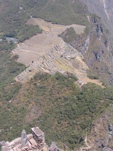
The view of Machu Picchu from the top of Waynu Picchu. The rumour is that the city is supposed to be shaped like a giant condor. I suspect it´s mostly peoples´ imaginations, but it´s a good story.This was a long day. Not only tired from the flight and lack of sleep, etc., we had to get up early (5 AM) to get the taxi to the train, which would take us to MachuPicchu through the sacred valley. We definitely took the most comfortable route, in the Vista Dome train, with other foreign tourists. Our seats were at the front of the rear car - kinda crappy, cause most of the view ended up being behind us. But, it was definitely worth the extra cost for larger (and cleaner) windows, and windows on the roof.
The trip out offered great views - of Cusco, and surrounding countryside, and spectacular mountains and cloud forest from within the sacred valley. 4 hours after leaving the city, we disembarked at Agues Calientes (hot springs at the base of the mountain where MachuPicchu is located). Talk about touristy! We had to navigate past the booths selling tourist souvenirs to get to the buses. It reminded me a lot like visiting Banff, in Canada. Everyone spoke English, as well, which is an indication of just how touristy it is.
Still, words can´t describe the feeling of walking in an intact Inca

 Sunrise over Cuzco
A view from the train climbing the switchbacks out of the city.city that was built 500 years ago, and deserted for about 400. The stonework is amazing, and the architecture is simple, but impressive. Although it was crawling with visitors, it remains an impressive sight and well worth the visit.
We began with our guided tour, which we paid for, but after just over a half-hour, we realized that just about everything we were being shown was either "for astronomical or religious" purposes. Mike, the archaeologist, translated this as meaning "the archaeologists don´t know, so it´s all speculation". So, we ditched the tour early to climb the trail and step to WaynuPicchu; "MachuPicchu" means "Old mounatin", and Waynupicchu" means "young mountain", although it´s taller. At the peak of this narrow mountain was another "astronomic observatory" and a few small buildings and terraces. The very top offered a spectacular view of the area, and the entire city of Machupicchu. It took us just under an hour to hike up, and we were sucking air most of the time, but it was well worth the effort, as everyone told us as they passed us on the way down.
This ended up taking up a lot of our time at the site,

 Sacred Valley
One of the spectacular mountains seen from inside the sacred valley.and once back, we walked quickly back towards the exit, grabbed a bus back, and had time to buy a few souvenirs. Be warned: the priced in this area are higher than in the smaller markets in Cusco, and the people much harder to bargain with, even though they speak english. And don´t tell them that Ecuador (or merchandise from Ecuador) is better: they get angry ;-)
The train ride back revealed more scenery, including stuff I had slept through on the way up, as well as a night-time view of Cusco as we arrived at the station. The city is surprizingly big, with a lot of sprawl from recent expansion. The return trip also featured a traditional dance and a fashoin show by the crew of alpaca clothing for sale. They were definitely catering to an audience with more money than we had.
We were home by 8 pm, had dinner and went straight to bed. A long day, but well worth it. I would have enjoyed it more had I spent at least another day at MachuPicchu, spent more time taking it in, and visiting the sun gate. We spoke to other folks who had just

 Rio Urubamba
The train to Machu Picchu follows the main river that flows through the valley.come off the Inka trail, which is definitely the more adventurous route, and probably safer now that groups such as the
Sendaro luminoso (sp?: "Shining Path") are less active. Sadly, our time in Peru is limited, and this had to do. I managed to max out my camera´s memory card during this single day, and had to switch to the backup. I have enough photos to hopefully make a VR thingy when I get home. I´m going to have to be very careful in the Galapgos, or hope someone on the boat has a computer I can use to transfer photos to my iPod. I´m looking for a certain Belkin accessory that can do the same thing directly, but I have a feeling it will be hard to find in Ecuador :-P
Advertisement
Tot: 0.139s; Tpl: 0.01s; cc: 6; qc: 44; dbt: 0.1067s; 1; m:domysql w:travelblog (10.17.0.13); sld: 1;
; mem: 1.1mb

 Machu Picchu!
 Sunrise over Cuzco
 Sacred Valley
 Rio Urubamba


