Advertisement
Published: September 30th 2017

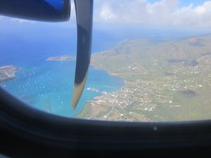
 The coast of Antigua
From our Early Liat flightGeo: 17.0833, -61.7
Here is a recap of what we did on our time on Antigua:
Arriving earlier than planned on Saturday at the VC Byrd Airport in Antigua, we drove to our B&B arriving around noon. After settling in we drove to the nearest restaurant, Mama's Homemade Pasta, at Long Bay beach. We had lunch and a then got a take out order of fettuccini and meatballs for our dinner that evening since the restaurant closed at 5:00 PM.
Sunday we drove to Indian Town National Park and did a bit of hiking around the Devil's Bridge coastal area and then along the shore of a small bay. Found a stash of hundreds of Conch shells on the shore there and got a few as souvenirs. Ate lunch on the shore of the bay - Anne had snacks and I finished her sandwich from the previous days lunch. Afterwards we took a scenic drive to the Falmouth Harbor area then back to the B&B.
Monday we had intended to do some hiking on some trails in the small rainforest area on Antigua where an old reservoir was located. However, true to its name, it was raining off and on making for

 The driveway to the Song of the Sea B&B
The drive led down the hill to just above the bayquite wet and muddy trails. We walked up to the old reservoir but then decided to revisit the Falmouth and English Harbor area and the Nelson's Dockyard National Park. Lots of beautiful views from the Dow's Hill and Shirley Heights area and a neat trail above the Nelson's Dockyard. After our hike and a late lunch we returned to our B&B.
Here are some pictures from our travels on Antigua.
Advertisement
Tot: 0.117s; Tpl: 0.05s; cc: 12; qc: 28; dbt: 0.054s; 1; m:domysql w:travelblog (10.17.0.13); sld: 1;
; mem: 1mb

 The coast of Antigua
 The driveway to the Song of the Sea B&B


