Advertisement
Published: April 12th 2018

 1
1
Harbour BridgeBlog 26
Part 1:
Auckland, New Zealand, April 9 ,2018 – Weather forecast: partly cloudy; passing showers; temperature 22°C, wind 9kts (3 Beaufort)
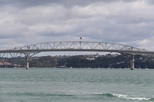
Auckland is situated on a narrow strip of land that forms the most northern peninsula on the North Island. Auckland, New Zealand’s largest city, is described as one of the loveliest cities in the world and according to a number of surveys, one of its most livable. Maori tribes settled the area as early as the 1300’s long before Europeans came in the 1840’s. Our docking berth was right in the core of the city giving us easy walking access to many sites.
Today the excursion John and I took promised to take us to some coastal fortifications. After boarding a twenty-passenger bus we followed a route from the dock area in central Auckland around the harbour to the North Shore and the suburb of Devonport. This was a bus tour with occasional short (15 minutes or less) stops for photo ops. Monday morning traffic, road construction, narrow streets all combined to slow our journey.
Eventually we did arrive at Fort Victoria overlooking Auckland’s harbour

 2
2
Black Swanfrom Devonport’s Flag Staff Hill. The volcanic hill was fortified in 1885 as the young colony thought it was going to be invaded by the Russian Pacific Fleet. The fortifications were all built below the top of the hill so that they were not visible from the harbour below. The site was protected with 8 inch disappearing guns that were raised to fire and the recoil depressed them back into their protective housing.
The tour ended with a ferry ride back across the harbour to the ferry dock beside our pier.
Brooke and Mary Ann took themselves out on a Hop-on Hop-off tour of the city with a stop at the Sky Tower where they had a wonderful overview of the city from a height of 326 meters (1,072 feet).
Later in the afternoon the captain announced that our next scheduled stop at Waitangi (Bay of Islands) was cancelled as the weather reports indicated that the area was going to experience extremely high winds and very rough seas. The captain opted to take us farther north in the hope that we could skirt the worst part of the storm and still

 3
3
Hidden fortmake it to Sydney by 3:00am on Friday morning.
Part 2:
At Sea – April 10-12, 2018; heavy overcast skies; torrential rain at times; average temperature 21°C, average wind speed 36kts (8 Beaufort) gusting to 55-65kts; ocean swell 4 to 8 meters;
As you can see by this weather report the last three days have been rough, but not as bad as what Auckland experienced. The news from the city indicated that they were hit by a wild storm packing winds of more than 200kmh (125mph). The storm hit during the night bringing down trees, peeling roofs from buildings and knocking power out to a quarter of the homes throughout New Zealand’s largest city. The captain’s decision to get us out of the area was a wise one.
Tomorrow is the end of this leg of the journey and our friends are leaving to return to Canada. They are joining roughly two thirds of the passengers who are leaving the ship in Sydney. They of course will be replaced by eager guests bound for Vancouver.
Advertisement
Tot: 0.042s; Tpl: 0.011s; cc: 9; qc: 23; dbt: 0.022s; 1; m:domysql w:travelblog (10.17.0.13); sld: 1;
; mem: 1mb

 1
1
 2
2
 3
3