COMING SOON HOUSE ADVERTISING ads_leader
Friday 5th August - 240kms We left Barmah at 1200 to go and stay overnight at Best Western near Tullamarine Airport, Melbourne. We dropped the car off at Easy Parking and they kindly took us to the motel instead of us having to go to the airport with them and then get the motel’s courtesy bus. The motel was very busy but the room was nice so we relaxed watching TV with a room service meal and a bottle of wine we brought with us.
Saturday 6th August We flew Qantas, which was concerning after hearing of all the horror stories. First we flew to Brisbane with no dramas and a surprisingly nice meal!!. The bus from the domestic to international terminals was slightly worrying as it kept passing turnoffs to the international terminal and headed for the shopping centre. We weren’t the only passengers voicing concerns but all went well even though we had little time to spare catching our connecting flight to Noumea. Naturally, we had to get Duty Free alcohol to see us through the week after checking in and were second last on the plane (Qantas).
On arriving in Nouméa, New Caladonia, we
 New Caledonia
we were in southern areacollected our one bag and found the car hire desk outside La Tontouta International Airport. The airport is in the municipality of Païta, approximately 52 kms northwest of Nouméa. It is the main international airport in New Caledonia, and the military base for the New Caldedonian Air Force. Tontouta Air Base was originally constructed by the United States Navy's Seabees for the Pacific Theatre of the Second World War.
We collected our red Renault Cleo and Danie got his first ever taste of driving on the “wrong” side of the road. Fortunately, the road was dual carriageway and not very busy, which was just as well. We had a very poor map from the car hire people and very little idea where we were going. Danie’s iPad came in useful and all we needed to do was follow the signs to Magenta domestic airport and then use it to find our hotel on Rue de la Riviera in a residential area. Le Stanley Hotel was not what we expected, rather run down with a very basic unit. However, it was large with separate bedroom, large bathroom with bath/shower and a very big balcony overlooking the ocean with lovely views.
Our Brave Little Car
Took us where little cars shouldn't go We spent quite a bit of time watching the paddle boarders, windsurfers, dinghies and yachts. There were also several small planes every and cargo ships and the ferry to Isle des Pines on the horizon. Not much in the way of sandy beaches on this southern part of the island.
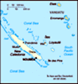
New Caledonia is a sui generis collectivity of overseas France in the southwest Pacific Ocean, south of Vanuatu, about 1,210 kms east of Australia, and 17,000 km from Metropolitan France. The archipelago, part of the Melanesia subregion, includes the main island of Grande Terre, where we stayed, the Loyalty Islands, the Chesterfield Islands, the Belep archipelago, the Isle of Pines, and a few remote islets. The Chesterfield Islands are in the Coral Sea. French people, especially locals, call Grande Terre "Le Caillou" ("the pebble").
New Caledonia has a land area of 7,172 sq miles, divided into three provinces. The North and South Provinces are on the New Caledonian mainland, while the Loyalty Islands Province is a series of islands off the mainland. New Caledonia's population of 271,407 (October 2019 census) is of diverse origins and varies by geography; in the North and in Loyalty Islands Provinces, the indigenous
Kanak people predominate, while the wealthy South Province contains significant populations of European (Caldoches and Metropolitan French), Kanak, and Polynesian (mostly Wallisian) origin, as well as smaller groups of Southeast Asian, Pied-Noir, and North African heritage. The capital of New Caledonia is Nouméa.
British explorer James Cook was the first European to sight New Caledonia, on 4 September 1774, during his second voyage. He named it "New Caledonia", as the northeast of the island reminded him of Scotland. The west coast of Grande Terre was approached by the Comte de Lapérouse in 1788, shortly before his disappearance, and the Loyalty Islands were first visited between 1793 and 1796 when Mare, Lifou, Tiga, and Ouvea were mapped by English whaler William Raven. Raven encountered the island, then named Britania, and today known as Maré (Loyalty Is.), in November 1793.From 1796 until 1840, only a few sporadic contacts with the archipelago were recorded. About 50 American whalers left record of being in the region (Grande Terre, Loyalty Is., Walpole and Hunter) between 1793 and 1887. Contacts with visiting ships became more frequent after 1840, because of their interest in sandalwood.
As trade in sandalwood declined, it was replaced by a
new business enterprise, "blackbirding", a euphemism for taking Melanesian or Western Pacific Islanders from New Caledonia, the Loyalty Islands, New Hebrides, New Guinea, and the Solomon Islands into slavery, indentured or forced labour in the sugarcane plantations in Fiji and Queensland by various methods of trickery and deception. Blackbirding was practised by both French and Australian traders, but in New Caledonia's case, the trade in the early decades of the twentieth century involved kidnapping children from the Loyalty Islands to the Grand Terre for forced labour in plantation agriculture. New Caledonia's primary experience with blackbirding revolved around a trade from the New Hebrides (now Vanuatu) to the Grand Terre for labour in plantation agriculture, mines, as well as guards over convicts and in some public works. In the early years of the trade, coercion was used to lure Melanesian islanders onto ships. In later years indenture systems were developed; however, when it came to the French slave trade, which took place between its Melanesian colonies of the New Hebrides and New Caledonia, very few regulations were implemented. This represented a departure from contemporary developments in Australia, since increased regulations were developed to mitigate the abuses of blackbirding and 'recruitment' strategies
on the coastlines.
The first missionaries from the London Missionary Society and the Marist Brothers arrived in the 1840s. In 1849, the crew of the American ship Cutter was killed and eaten by the Pouma clan. Cannibalism was widespread throughout New Caledonia.
On 24 September 1853, under orders from Emperor Napoleon III, Admiral Febvrier Despointes took formal possession of New Caledonia. Captain Louis-Marie-François Tardy de Montravel founded Port-de-France (Nouméa) on 25 June 1854. A few dozen free settlers settled on the west coast in the following years. New Caledonia became a penal colony in 1864, and from the 1860s until the end of the transportations in 1897, France sent about 22,000 criminals and political prisoners to New Caledonia. The Bulletin de la Société générale des prisons for 1888 indicates that 10,428 convicts, including 2,329 freed ones, were on the island as of 1 May 1888, by far the largest number of convicts detained in French overseas penitentiaries. The convicts included many Communards, arrested after the failed Paris Commune of 1871, including Henri de Rochefort and Louise Michel. Between 1873 and 1876, 4,200 political prisoners were "relegated" to New Caledonia. Only 40 of them settled in the colony; the
rest returned to France after being granted amnesty in 1879 and 1880.
In 1864, nickel was discovered on the banks of the Diahot River; with the establishment of the Société Le Nickel in 1876, mining began in earnest. To work the mines the French imported labourers from neighbouring islands and from the New Hebrides, and later from Japan, the Dutch East Indies, and French Indochina. The French government also attempted to encourage European immigration, without much success.
The indigenous Kanak people were excluded from the French economy and from mining work, and ultimately confined to reservations. This sparked a violent reaction in 1878, when High Chief Ataï of La Foa managed to unite many of the central tribes and launched a guerrilla war that killed 200 Frenchmen and 1,000 Kanaks. A second uprising occurred in 1917, with Protestant missionaries like Maurice Leenhardt functioning as witnesses to the events of this war. Leenhardt would pen a number of ethnographic works on the Kanak of New Caledonia. Noël of Tiamou led the 1917 rebellion, which resulted in a number of orphaned children, one of whom was taken into the care of Protestant missionary Alphonse Rouel. This child, Wenceslas Thi, would
become the father of Jean-Marie Tjibaou (1936–1989).
Europeans brought new diseases such as smallpox and measles, which caused the deaths of many natives. The Kanak population declined from around 60,000 in 1878 to 27,100 in 1921, and their numbers did not increase again until the 1930s.
In June 1940, after the fall of France, the Conseil Général of New Caledonia voted unanimously to support the Free French government, and in September the pro-Vichy governor was forced to leave for Indochina.
In 1941, some 300 men from the territory volunteered for service overseas. They were joined, in April, by 300 men from French Polynesia ('the Tahitians'), plus a handful from the French districts of the New Hebrides: together they formed the Bataillon du Pacifique (BP). The Caledonians formed two of the companies, and the Polynesians the other two. In May 1941, they sailed to Australia and boarded the RMS Queen Elizabeth for the onward voyage to Africa. They joined the other Free French (FF) battalions in Qastina in August, before moving to the Western Desert with the 1st FF Brigade (1re BFL). There they were one of the four battalions who took part in the breakout after the
Battle of Bir Hakeim in 1942. Their losses could not easily be replaced from the Pacific and they were therefore amalgamated with the Frenchmen of another battalion wearing the anchor of 'la Coloniale', the BIM, to form the: Bataillon de l'infanterie de marine et du Pacifique (BIMP). The combined battalion formed part of the Gaulliste 1re Division Motorisée d'Infanterie/Division de Marche d'Infanterie (DMI), alongside three divisions from the French North African forces, in the French Expeditionary Corps (CEF) during the Italian Campaign. They landed in Provence in 1944, when they were posted out and replaced by local French volunteers and résistants.
Meanwhile, in March 1942, with the assistance of Australia, New Caledonia became an important Allied base and the main South Pacific Fleet base of the United States Navy in the South Pacific moved to Nouméa in 1942–1943.The fleet that turned back the Japanese Navy in the Battle of the Coral Sea in May 1942 was based at Nouméa. American troops stationed on New Caledonia numbered as many as 50,000, matching the entire local population at the time
In 1946, New Caledonia became an overseas territory.1953, French citizenship had been granted to all New Caledonians, regardless of ethnicity.
Another Balcony View
We had a big balcony During the late 1940s and early 1950s, New Caledonia strengthened its economic links with Australia, particularly as turmoil within France and its empire weakened New Caledonia's traditional economic links to metropolitan France; New Caledonia supplied nickel to Australia in exchange for coal vital for smelting nickel. New Caledonian exports of iron ore and timber to Australia also increased during this time period.
The European and Polynesian populations gradually increased in the years leading to the nickel boom of 1969–1972, and the indigenous Kanak Melanesians became a minority, though they were still the largest ethnic group.
Between 1976 and 1988, conflicts between French government actions and the Kanak independence movement saw periods of serious violence and disorder. In 1983, a statute of "enlarged autonomy" for the territory proposed a five-year transition period and a referendum in 1989. In March 1984, the Front Indépendantiste, a Kanak resistance group, seized farms and the Kanak and Socialist National Liberation Front (FLNKS) formed a provisional government. In January 1985, the French Socialist government offered sovereignty to the Kanaks and legal protection for European settlers. The plan faltered as violence escalated. The government declared a state of emergency; however, regional elections went ahead,
and the FLNKS won control of three out of four provinces. The centre-right government elected in France in March 1986 began eroding the arrangements established under the Socialists, redistributing lands mostly without consideration of native land claims, resulting in over two-thirds going to Europeans and less than a third to the Kanaks. By the end of 1987, roadblocks, gun battles and the destruction of property culminated in the Ouvéa cave hostage taking, a dramatic hostage crisis on the eve of the presidential elections in France. Pro-independence militants on Ouvéa killed four gendarmes and took 27 hostage. The military assaulted the cave to rescue the hostages. Nineteen Kanak hostage takers were killed and another three died in custody, while two soldiers were killed during the assault.
The Matignon Agreements, signed on 26 June 1988, ensured a decade of stability. The Nouméa Accord, signed 5 May 1998, set the groundwork for a 20-year transition that gradually transfers competences to the local government
Following the timeline set by the Nouméa Accord that stated a vote must take place by the end of 2018, the groundwork was laid for a referendum on full independence from France at a meeting chaired by the
French Prime Minister Édouard Philippe on 2 November 2017, to be held by November 2018. Voter list eligibility was the subject of a long dispute, but the details were resolved in an electoral list that granted automatic eligibility to voters of Kanak origin but excluded those of other origins who had not been longtime residents of the territory. The referendum was held on 4 November 2018, with independence being rejected.
Another referendum was held in October 2020, with voters once again choosing to remain a part of France. In the 2018 referendum, 56.7% of voters chose to remain in France. In the 2020 referendum, this percentage dropped with 53.4% of voters choosing to remain part of France.
The third referendum was held on 12 December 2021. The referendum was boycotted by pro-independence forces, who argued for a delayed vote due to the impact caused by the COVID-19 pandemic; when the French government declined to do so, they called for a boycott. This led to 96% of voters choosing to stay with France
New Caledonia is part of Zealandia, a fragment of the ancient Gondwana super-continent. It is speculated that New Caledonia separated from Australia roughly 66 million
years ago, subsequently drifting in a north-easterly direction, reaching its present position about 50 million years ago.
The mainland is divided in length by a central mountain range whose highest peaks are Mont Panié (1,629 m) in the north and Mont Humboldt (1,618 m) in the southeast. The east coast is covered by a lush vegetation. The west coast, with its large savannahs and plains suitable for farming, is a drier area. Many ore-rich massifs are found along this coast.
The Diahot River is the longest river of New Caledonia, flowing for some 100 kilometres.It has a catchment area of 620 km2 and opens north-westward into the Baie d'Harcourt, flowing towards the northern point of the island along the western escarpment of the Mount Panié. Most of the island is covered by wet evergreen forests, while savannahs dominate the lower elevations. The New Caledonian lagoon, with a total area of 24,000 square kilometres is one of the largest lagoons in the world. The lagoon and the surrounding New Caledonia Barrier Reef was named a UNESCO World Heritage Site in 2008 for its exceptional beauty and marine biodiversity.
New Caledonia has many unique taxa, especially birds and plants.
It has the richest diversity in the world per square kilometre. The biodiversity is caused by Grande Terre's central mountain range, which has created a variety of niches, landforms and micro-climates where endemic species thrive.
Largely due to its nickel industry, New Caledonia emits a high level of carbon dioxide per person compared to other countries. In 2019 it emitted 55.25 tons of CO2 per person, compared to 4.81 for France. The combination of the exceptional biodiversity of New Caledonia and its threatened status has made it one of the most critical biodiversity hotspots on Earth.
New Caledonia's fauna and flora derive from ancestral species isolated in the region when it broke away from Gondwana many tens of millions of years ago .It is the only endemic species to have evolved here, but entire genera, families, and even orders are unique to the islands.
More tropical gymnosperm species are endemic to New Caledonia than to any similar region on Earth. Of the 44 indigenous species of gymnosperms, 43 are endemic, including the only known parasitic gymnosperm (Parasitaxus usta).Also, of the 35 known species of Araucaria, 13 are endemic to New Caledonia. New Caledonia also has the world's
most divergent lineage of flowering plant, Amborella trichopoda, which is at, or near, the base of the clade of all flowering plants.
The world's largest extant species of fern, Cyathea intermedia, also is endemic to New Caledonia. It is very common on acid ground and grows about one metre per year on the east coast, usually on fallow ground or in forest clearings. There also are other species of Cyathea, notably Cyathea novae-caledoniae. New Caledonia also is one of five regions on the planet where species of southern beeches (Nothofagus) are indigenous; five species are known to occur here.
Two terrestrial ecoregions lie within New Caledonia's territory: New Caledonia rain forests and New Caledonia dry forests.
In addition to its outstanding plant diversity and endemism, New Caledonia also provides habitat for a wide diversity of animals. Over 100 bird species live in New Caledonia, of which 24 are endemic.One of these endemic bird species is the New Caledonian crow, a bird noted for its tool-making abilities, which rival those of primates. These crows are renowned for their extraordinary intelligence and ability to fashion tools to solve problems, and make the most complex tools of any animal yet
Wind Farm
Our little car ade it up here along gravel roads studied apart from humans.
The endemic kagu, agile and able to run quickly, is a flightless bird, but it is able to use its wings to climb branches or glide. Its sound is similar to the bark of a dog. It is the surviving member of monotypic family Rhynochetidae, order Eurypygiformes.
There are 11 endemic fish species and 14 endemic species of decapod crustaceans in the rivers and lakes of New Caledonia. Some, such as Neogalaxias, exist only in small areas. The nautilus—considered a living fossil and related to the ammonites, which became extinct at the end of the Mesozoic era—occurs in Pacific waters around New Caledonia. There is a large diversity of marine fish in the surrounding waters, which are within the extents of the Coral Sea.
Despite its large number of bird, reptile, and fish species, New Caledonia has remarkably few mammal species: nine, of which six are endemic.
Several species of New Caledonia are remarkable for their size: Ducula goliath is the largest extant species of arboreal pigeon; Rhacodactylus leachianus, the largest gecko in the world; Phoboscincus bocourti, a large skink thought to be extinct until rediscovered in 2003.
Much of New
Caledonia's fauna present before human settlement is now extinct, including Sylviornis, a bird over a metre tall not closely related to any living species, and Meiolania, a giant horned turtle that diverged from living turtles during the Jurassic period.
Financial support from France is substantial, representing more than 15%!o(MISSING)f the GDP, and contributes to the health of the economy.] Tourism is underdeveloped, with 100,000 visitors a year, compared to 400,000 in the Cook Islands and 200,000 in Vanuatu. Much of the land is unsuitable for agriculture, and food accounts for about 20%!o(MISSING)f imports. New Caledonia is a significant producer of: yams (33rd); taro (44th); plantains (50th); coconuts (52nd).
Sunday 7th August Today we went to Dumbéa where we went to a supermarket to buy baguettes and other food. Dumbéa is a commune in the suburbs of Nouméa in the South Province. The population of the commune was 35,873 according to the 2019 census.
We couldn’t get any of the local currency The CFP franc (French: Franc pacifique, called the franc in everyday use). It is the currency used in the French overseas collectivities of French Polynesia, New Caledonia, and Wallis and Futuna. The
initials CFP stand for Change franc Pacifique
We had to wait until Monday to go to a bank as unavailable in Australia. Had to use the credit card !!! Neither could we get money exchanged at the hotel today and also had to ask for cutlery and cooking utensils as non in our room but it was cleaned daily with fresh bed linen and towels.
Monday 8th August Today we drove south to Mont-Dore with a population of 27,620 it is the second largest city in New Caledonia. Several sites in the town of Mont-Dore have been populated for a long time. The first settlement areas were located including Boulari and St. Louis from the time of the period Koné back to the beginning of the first millennium BC. Another site, that of Plum, gave his name to a style of pottery developed between the second century BC and the beginning of the second millennium AD.
We called in to the Information Bureau and got a better map and a great restaurant recommendation which we went to twice. Most eating places close at 1330 and reopen at 1800 and we didn’t want to do any night
driving so missed out on lunch today. I have to say my French came in very useful as Danie speaks none at all. He will come into his own in South Africa.
The weather was not really too warm but much nicer than back in Australia so we were able to wear summer clothes. The food selection in the supermarkets is very good with lots of New Zealand imports like UHT milk (no fresh milk available) and beef. Bread is baked twice a day and the wine is mainly French and very reasonably priced. The cheese and salami offerings were huge and we bought lots to go with our daily baguette, which we had for nightly nibbles.
We found a local small Carrefour Express (supermarket) near the hotel which was very useful and everyone was so friendly.
Tuesday 9th August Today we went back to Mont-Dore and had lunch at La Pootte, a very French restaurant catering for locals. It was very reasonable and Danie’s entrecote steak was cooked to perfection as was my pork fillet. We had the local Number One beer which we liked very much and had a slab in our room. The
staff were lovely and spoke little English but I was able to translate the menu which was written up on a blackboard and brought to the table.
After a beautiful lunch we went for a drive along the coast to Plum, a coastal village just north of Pirogues Bay. The Plum River empties into the sea near the western part of the village and Lucky Creek flows into the sea to the southeast. Important chrome discoveries were made in the area in the late 19th century. Then to Prony. In 1854 the Prony corvette left the Nouméa strait to explore the southern coasts. Travelling along the Woodin Canal between the Grande Terre and Ouen island, its captain Jean-Joseph de Brun, discovered a huge bay that he named after his ship.
The development of Nouméa city was constantly increasing the need for building materials, hence the decision was made in 1867 to send a team of 33 men to the bay, 29 of them “transported,” that is, convicts. There, they would set up a work camp called Sebert camp, intended to exploit the bay’s forestry resources.
Before getting to Prony we turned left to follow the road towards
Yaté, which looked perfectly fine on the map………wrong! After only a few kilometres the bitumen turned into muddy red gravel road with huge (for our little car) potholes. Nevertheless, we carried on and the scenery was wonderful, except for the minesites. The Goro mine is a large nickel mine, near the township of Yaté, Prony Bay. It was owned by the Brazilian company Vale, who, after failing to sell it to Melbourne-based New Century Mining in June 2020 sold it to Prony Resources New Caledonia consortium in April 2021. The large mine and plant was opened at Goro in 2010 although it has had frequent problems and stoppages.
Goro is one of the largest nickel reserves in New Caledonia, which has 25%!o(MISSING)f world nickel reserves. Goro has estimated reserves of 370 million tonnes of ore grading 1.6%!n(MISSING)ickel. The 370 million tonnes of ore contains 5.92 million tonnes of nickel metal.
The Goro mine is targeted to produce about 40,000 tonnes of nickel per year, and also some cobalt from saprolite deposits. It was designed by the Canadian company Inco, and completed by the Brazilian company Vale after it purchased Inco. Ore comes from a huge open
cut mine on the Plaine des Lacs. Nickel and cobalt are delivered by conveyor to Prony Bay. The processed high grade nickel oxide is then shipped to Vale's refinery in Dalian, China. Vale held a 69%!s(MISSING)hare and a joint company called Sumic Nickel Netherlands, Japan's Sumitomo Metal Mining Co. Ltd., and Mitsui Co. Ltd., held a 21%!s(MISSING)hare. The three provinces of New Caledonia held the remaining 10%! (MISSING)
The US$6 billion mine and nickel processing plant has had a chequered history. It is in a remote location with an indigenous Kanak population who were largely engaged in fishing and agriculture, with limited mining, prior to the plant. It was opposed by many of the indigenous residents for some years, led by the Rheebu Nuu committee, and sabotage at the construction site caused significant delays. Rheebu Nuu used the Declaration of 2002 and the United Nations Declaration on the Rights of Indigenous Peoples of 2007 in order to claim land rights (as material and immaterial property) and compensation payments. A turnaround in negotiations occurred in 2008. Rheebu Nuu and Vale signed a “Pact for Sustainable Development of the Big South” in March 2008 that managed the question of royalties.
Rheebu Nuu then stopped legal measures against Vale Inco and accepted a discharging of highly dilute acid in the southern Caledonian lagoon. The project was always supported by the mining friendly Southern Province.
The plant uses a high-pressure-acid-leach (HPAL) technology, deemed expensive and prone to problems. It opened in 2010 after substantial delays and an acid spill in April of that year. Sulfuric acid is made and stored on site to leach nickel out of the ores; waste material is stored and clean effluent is emitted through a long pipe into the sea. In 2012 the whole facility was out of action for six months following spills. Environmental groups and local people feared effluent emissions could damage the fragile lagoon system offshore, vital for local livelihoods and also a UNESCO World Heritage site. Their fears were again confirmed in May 2014 when 100,000 litres of effluent ended up in a creek. At this time the plant was shut down after arson attacks by local Melanesian youths, causing $20–30 million of damage. A joint mission by the provincial government and the environmental authority are investigating the extent of pollution and plant performance.
On 2016, a
loan from the French Government was made to help the mine overcome their sustained losses since its opening. Vale announced its desire to sell the operation to New Century Mining in June 2020,but the company was unable generate the required funding for the acquisition, and its board elected not to pursue the acquisition.
In 2021 the mine contracted to supply nickel to Tesla, Inc., up to third of its production over the next five years. Sustainable development is a goal of Tesla.
We also passed Prony and Kafeate Windfarm near Col de Preny (328m), a mountain with a lookout near the summit, which is located is located in a hurricane hot spot; the wind turbines used in the project are specifically designed for this type of climate, meaning that the whole wind farm can be tilted down within a few hours in the event of an extreme weather alert. In addition, to strengthen civil society and indigenous Kanak rights, the project supports local and regional initiatives addressing employment, youth and community activities. Furthermore, the infrastructure of the wind farms is based on existing roads only to limit erosion and the project now serves as an example for similar
projects throughout the South Pacific, and is seen as a symbol of environmentally respectful development that is sensitive to the needs of local tribes.
Not only did we negotiate, mud and potholes but had 6 creek crossings to contend with, cars speeding towards us, the odd truck too. We eventually left the twists and turns and steep roads and turned onto the main road back to Mont-Dore. The road went along the side of Lake Yaté, an artificial lake with an area of about 4,000 ha located in Grande Terre on the territory of the municipality of Yaté. It is the largest body of fresh water in New Caledonia.It is located at an altitude of about 160 m, in the town of Yaté. Dominated by the Central Range (a mid-mountain range extending over the entire length of the island of Grande Terre of which it constitutes the "backbone") and its foothills to the north and west, it is bordered to the south by the so-called Grand Sud region, a vast area of plains and hills with a dense hydrographic network and ferrous soil covered with vegetation known as the "mining maquis".
The dam is fed by various
streams and rivers that have their source in the foothills and peaks of the Central Chain to the north, or in the isolated hills to the south. The most important of these are the Blanche River to the west (which forms a marsh before flowing into the lake), the Blue River to the northwest (it gives its name to the Blue River Provincial Park extending north and west of the lake while its mouth is marked by the presence of many dead trees submerged during the construction of the dam on its course, this area has since been called the "Drowned Forest" and is a tourist hotspot for hikers and kayakers or The Pernod Creek and the Lakes River to the south. The regular opening of the dam's valves maintains the level of the lake and feeds a network of streams and waterfalls that run downstream to the sea under the name of Yaté River.
It has a very cut and spread shape, extending for 22 km along an east-west axis, and for 6.5 km for its maximum width from north to south. Several small islets line the lake's body of water. Provincial Road 3, which connects the agglomeration
of Mont-Dore to the village of Yaté, runs along its south shore.
It is an artificial lake whose Yaté dam was built in 1959 on the course of the Blue River, in order to meet the significant demand for electricity from the Doniambo nickel processing plant in Noumea.
Lake Yaté is also very famous in the local sport fishing community for its large population of black bass, this fish having been imported and introduced into the lake to populate it. This predator has since spread into New Caledonian waterways, threatening native and endemic fish. The Sport Fishing Association of New Caledonia (APS-NC) was originally created to regulate the black-bass population in the lake, which remains a hotspot for fly fishing.
Deer are very common and we passed three locals walking along the road with their guns. This road was sealed but still very hilly with many twists and turns and maniac drivers. We eventually made it back to the hotel after an amazing day out.
Wednesday 10th August Today we headed north to the tourist area of Baie des Citrons which is quite close to us, south of the city. There is one hotel on
the edge of the ocean (the Meridian) and the other big names are away from the coast. There is also the Îlot Maître located on an island of white sand and turquoise lagoon in front of Baie de Citrons. Archetype of the dream of the South Seas, the islet Master floats like a mirage on the lagoon.It is in the heart of an exceptional marine reserve of 200 hectares, just 20 minutes from Noumea by boat
There is not much in the way of beaches but plenty of marinas. We headed for a restaurant we had read about, the Baie de l’ Orphelinat, the Marmite et Tire Bouchon. Definitely tourist prices but fabulous food, I had slow cooked guinea fowl and Danie had shredded pork and prawns. The French waiter was so attentive, he had been in Sydney working and wanted to go and see Europe as he was born in New Caledonia. We had a window seat overlooking the local marina. W
Later we had a walk after lunch but were not impressed with the touristy feel so went back to the hotel for a nap.
Thursday 11th August Today it got very windy so we only went as far Ouen Toro, a 132 metre high hill which we can see from our balcony. The name Ouen Toro comes from the Nââ drubéa language and means "ironwood hill" and it is a great lookout over Noumea.
The subsoil of Ouen Toro is composed of schists, limestones, sandstones, silica and phtanites. It is poor, friable and susceptible to erosion. On the White Coast, which corresponds to the southeastern edge of the hill, deep crevices can be seen4.
Ouen Toro Park is covered with anthropized vegetation and a sclerophyll forest more or less degraded, including about 3 hectares of dry forest. Some areas are grassed, namely the three peaks of the hill and the talweg that separates the two southernmost peaks, and constitute an access route from the Côte Blanche car park.
Invasive species are present throughout Ouen Toro, including false mimosa, false pepper tree and Passiflora suberosa
The portions of dry forest present on the Ouen Toro are composed of 35 species of which 18 are endemic and 4 threatened with extinction.Intensive human attendance contributes to forest degradation.
A military base was established in Ouen Toro in 1891. A battery was installed there a year later.The eastern slopes of the Ouen Toro overlooking the Pierre Vernier promenade. A silica mine was set up and made it possible to build the Pierre Vernier promenade in 1933. The Ouen Toro also housed a military base during World War II, as evidenced by the presence of cannons located at its highest peak. They were installed there in 1941 by the Australian Army .Beginning in 1964, real estate construction began to encroach on areas north and east of the hill.In December 2019, the Ouen Toro suffered several arson attacks.
The Ouen Toro is partly built of collective residences or individual habitats, especially on its northern and eastern flanks.
From an environmental point of view, the Ouen Toro area has been the subject of protection measures since 1982. In 1989, it was classified as a provincial park.
Since at least 2005, actions to eradicate invasive species have been taking place. Since 2007, there have also been reforestation projects with dry forest species.
We had lunch at a seafood restaurant overlooking the marina where we shared a seafood platter.
Friday 12th August Another windy day so we didn’t do very much, went to the car wash, bought fresh baguettes from the bakery filled up with fuel and had marlin steaks for lunch,
Saturday 13th August Leaving New Caledonia today. We had a great week and enjoyed our stay but had we known better we would not have based ourselves in one place rather travel up the long island so we didn’t have to back track every day, staying in places up the island.
We went to check in at the Aircalin desk only to be told we were not on the list!!!!!!! Spent ages at the office speaking to Qantas in Sydney on the phone. We had flight confirmation paperwork but the Qantas man would not let us on the flight and rebookd us on a later flight as he said our original flight was full. This meant we had a four-hour wait at Tortouta International Airport and missed our connecting flight from Sydney to Melbourne – another 3 hour wait, fortunately in the Priority Pluss lounge.
We stayed at the Best Western Motel in Melbourne Tullamarine airport picking up the car from the parking place using their shuttle service and driving to the motel picking up pizza en route.
Sunday 14th August (239 kms) - Wednesday 24th August A very chilly 14C today in Barmah. We spent the next week doing last minute jobs before setting off on our main adventure………………………………
COMING SOON HOUSE ADVERTISING ads_leader_blog_bottom
Tot: 0.154s; Tpl: 0.021s; cc: 9; qc: 49; dbt: 0.0422s; 1; m:domysql w:travelblog (10.17.0.13); sld: 1;
; mem: 1.2mb