Advertisement
Published: February 11th 2011

 'On Occupied Territory'
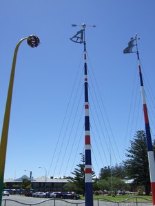
At the top of the poles is an octant, an anemometer and the top of the knobby club rush as explained on the plaqueOn Sunday 6th February we said a fond farewell to Meningie and set off towards Goolwa. We passed the Pink Lake again and this time stopped to take a photo although it didn’t seem quite so pink this time. At Wellington we had the opportunity of going via another free cable ferry and saving ourselves quite a few kms. Graham was a bit concerned, because of the uneven slope on and off the ferry, that the base of the caravan would hit the ground and it did but not enough to do any damage thankfully. There was only one other vehicle on the ferry with us but there was a long queue on the other side and quite a few were cars with caravans. The crossing only took a few minutes and then we were on our way again. We went through Strathalbyn, a very Scottish town where we stayed last time, and would have stopped for a break except that we missed the parking place for cars and caravans so we carried on until we got to Goolwa.
There were a couple of caravan parks in the town and we decided to go to the ‘Family Parks’ one which
was just one kilometer from the centre. It was in a flat, fairly residential area but the CP itself was tidy and the site we were given was large and grassy. It didn’t take long to set up and then we were able to relax a bit and eat our sandwiches. There was plenty of time then to go into town and visit the Information Centre. We chatted to the young lady there about various opportunities and after some discussion we booked a six hour ‘adventure cruise’ that went into the Coorong National Park. The next available trip went on Wednesday. It was very expensive and there was no reduction for UK pensioners but it was something we really wanted to do. From there we wandered over to the nearby train station where we knew the historic steam train was running that day because we’d seen it a few minutes earlier and had heard its regular whistle blowing. One of the railway volunteers rushed out to greet us and when he told us the next train service was on Wednesday we were a bit disappointed as that was the day of our cruise.
We strolled back to the main
street and popped into a café for tea and scones. The walls were plastered with huge adverts for ‘Kettle Chips’ - we should have asked if they had any spare posters but sometimes we are a bit slow ‘in coming forwards’ so we didn’t’!
Goolwa is situated in an interesting position near the mouth of the Murray River. In December 1934 work commenced on the construction of a permanent barrage between Hindmarsh Island and Sir Richard Peninsula on the south eastern outskirts of Goolwa. There are five barrages in the system and the work was completed in 1940. The barrages separate the fresh water of the River Murray from the tidal salt water coming up from the Murray mouth. The main barrage, the Goolwa Barrage, which is 632 metres long is made up of many concrete gates each a couple of meters wide, was constructed to prevent the salt water going further up the River Murray and polluting the much needed fresh water. The flow of water out into the ocean, and the level of water in Lakes Albert and Alexandrina which we had visited during our stay a Meningie, is controlled by the number of gates open at
any given time.
In the evening we drove along past the barrage as far as the road went and sat and watched the pelicans and terns. Then a young French chap came over and asked if we’d seen the seal – no we hadn’t! He pointed it out – it was some way away by that time and we didn’t get a decent photo. He also told us that he’d seen a bird which he didn’t know. He insisted on drawing the shape of the beak because he couldn’t think of the correct English word. Eventually we realized that he’d seen a Spoonbill! Alas, it was now so far away that we couldn’t see it properly!
On Monday we drove the 20 kms to Victor Harbour where we had stayed for a couple of nights on our last trip. The weather hadn’t been too good then but today was a bright, sunny, slightly chilly but very pleasant day. All we remembered about the last trip was that we went on the horse drawn tram across the causeway to Granite Island and got soaked! This time it was delightful and we shared the upper deck with a young family
from Hamilton, a place we had stayed at a week or two previous. The tram stopped conveniently by the island café so we paused there to have a cuppa. While we were sat looking out to sea we saw another seal frolicking not far away by the rocks. We strolled around the headland for a good hour or so – the scenery was magnificent and the view from the highest lookout back towards Victor Harbour was glorious. We walked backed across the causeway where we had come on the tram. After lunching in VH’s main touristy street, some tall structures caught our attention so we strolled to where they were – the main inscription on the front summed it all up nicely: ‘On Occupied Territory’. A plaque described the meaning of each of the poles which were painted to represent flags and another plaque included ‘an expression of sorrow and an apology to the local Ngarrindjeri people’ - it was all very profound stuff. Back where the car was parked were several war memorials one of which was for Aussie soldiers who had died at Long Tan in Vietnam in 1966. We tend to forget the huge price Australia has
paid in supporting their allies over the years. We meandered back to Goolwa, stopping at Port Elliot which was to become one of our regular haunts during our stay in the area.
In the evening we went back to the barrage and, seeing that the complex was still open, we went in and strolled along the walkway. At about the halfway point there was a lock gate which was as far as people were allowed to walk. About a third of the barrage gates were open and it was fascinating watching the pelicans lining up by the open sections scooping up fish as they came through. The nearby information boards gave us the history and workings of the barrage. There was a picnic area there with free barbecues and, apparently, it’s a very popular place for locals to gather.
We decided to have a quietish day on Tuesday. We thought about cycling to Hindmarsh Island but it is quite a big island so we drove there instead (oh dear!). It’s an area being developed at the moment with a swanky new marina and houses with access to water frontage and individual moorings. We drove on to a lookout
which was immediately opposite the ‘Mouth of the Murray River’ – an area we were to get very close to and learn a lot about on our cruise the following day. Hindmarsh Island is largely farming territory and as there didn’t seem too much more of interest to see we went off to Port Elliot, bought some rolls in the famous bakery and went to find the lovely spot we had come across before. We went down the wrong road and came out at another lookout overlooking the surfing beach so we still had our lunch with a view, just not the one we intended! Later on we managed to find the right place and stayed there for a while. Looking through our binoculars we could see a couple of seals in the sea by some rocks and then I spotted one sunbathing out of the water – how lovely! We looked down over Horseshoe Bay towards the main beach in Port Elliot. This area is part of Encounter Bay which is named after the encounter on 8 April 1802 between Matthew Flinders and Nicolas Baudin, both of whom were charting the Australian coastline for their respective countries (Britain and
France). The encounter between the scientists was peaceful, even though their countries were at war at the time.
Eventually we went down to the beach where there were gangs of school children taking part in lots of different beach sports, some of which involved boogy boarding round their teachers who were stood chest deep in the ocean. It was all very energetic but was great fun to watch and all the kids looked to be having a great time. We just sat and relaxed and enjoyed some ice-creams at the same time.
Without trying too hard we’d learnt quite a lot about the area and had had a great day!
Advertisement
Tot: 0.065s; Tpl: 0.013s; cc: 10; qc: 30; dbt: 0.0358s; 1; m:domysql w:travelblog (10.17.0.13); sld: 1;
; mem: 1.1mb


