Advertisement
Published: December 18th 2007

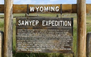
 The Sawyer Expedition
At this spot near the Tongue River, Colonel J A Sawyer's Wagon Train and Road Building Expedition of 82 wagons fought the Arapahoe Native Americans for 13 days, between 31 August to 12 September 1865.Today we head North West on I 90 for Red Lodge by crossing the Bighorn Mountains. We’re just a little sad that we could not fit in a visit to the Little Bighorn Battlefield National Monument. It was just too much, distance wise. We turn off at Ranchester, fuel up at Dayton then over the Big Horn Mountains on Scenic Road US 14. The views are tremendous.
We’re quickly on to broad sweeping hairpins (switchbacks) as the road rises quickly. To our surprise there are some fantastically rich alpine meadows up here with many different species of flower, lupine being prominent. It’s quite a wide plateau and the road is nearly empty. Near Burgess Junction, where we stop for a walk, the road splits into US 14 and US 14a. Both roads are said to be scenic so we try a little of 14, the top part not being that interesting so we return and go down 14a, which is very scenic. Near Medicine Wheel Passage, we head up the mountain to see the Medicine Wheel, an ancient stone circle, but it is going to be 1.5 hours walk from the ranger cabin and we can’t fit it in -

 The Bighorn Mountains from near Dayton
Not far from the Sayer's Expedition Sign.drat! Heading back down we stop for a bite to eat, soaking up the fantastic views, when suddenly these Hells Angels join us. They must think this is the Medicine Wheel stop. We feel a little threatened and clear off. They seemed nice guys, really!
As we start to go downhill, we’re busy taking photos, David on the video, when this young moose trots out of the forest. Unfortunately, it quickly dashes back again when it saw us so we only got a little video scene, mainly of its rear!
The journey down the west side towards the Bighorn National Recreation Area, has tremendous sweeping hairpins. But the lower basin looks arid, whereas the east side was lush and green. Drive through Lovell and Frannie, which is not that scenic, then over to Red Lodge, which looks a nice place. It’s an old mining area that has developed into a skiing centre.
After registering at the Best Western Lupine Inn, it’s a walk around town and a Chinese meal, which was delicious. The Inn staff are very friendly and accommodating, allowing us to put our perishable foods in their fridge for the night, many thanks to them.
Oh! The free internet lets us stay in touch with the outside world as well.
Advertisement
Tot: 0.179s; Tpl: 0.016s; cc: 11; qc: 31; dbt: 0.1269s; 1; m:domysql w:travelblog (10.17.0.13); sld: 1;
; mem: 1mb

 The Sawyer Expedition
 The Bighorn Mountains from near Dayton


