Advertisement
Published: October 18th 2009

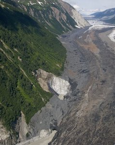
 Looking Northwest along the Desolation Valley
Western river of the Lituay Glacier outwash plain in the foreground. Desolation Lake in the top of the photo. The outburst river is most likely under the ice more or less near the base of the vegetated slope"He says Lituya Bay is full of ice and we won't be able to land." I sat in the copilot's seat in shock. The float plane was over Lake Crillon and we would reach Lituya Bay in minutes, expecting to land and begin a week of wilderness adventure. Seems the adventure was already in full swing.
"I'm on the radio with another pilot and he says it was clear yesterday but today it is full of ice." I mumbled into the headset microphone, "He's pulling your leg Cable." Where could that much ice come from? We'd walked the faces of both glaciers at the head of Lituya Bay the year before. Many years ago they were significantly tidewater, but in 2008 Lituya Glacier was back a quarter mile or more from the ocean and just a small portion of North Crillon Glacier touches sea water at high tide. Lituya Bay is big, as in 9 miles long and up to 2 miles wide. To 'fill' it with ice would take a whole lot of ice. To fill it over night seemed impossible. But I should have known... I'd been there...
When the plane banked into the back end of
the Bay I could see the icebergs in the murky, swirling water, and yeah, at the back of the bay they were thick. But I could also see up the Desolation Valley, across the outwash plain of the Lituya Glacier, across last years' campsite and along the glacial rivers that drain the east and west sides of the glacier. The eastern river looked about the same as it had last year, but the western river was raging. 150 feet wide and boiling yet we'd rock-hopped it the year before. On the outwash plain on either side of the river I could see the bright white dots of stranded icebergs. And then I knew that we were witnessing an 'outburst flooding event'.
Big glaciers can act like big dams. Where they pinch off a valley a 'glacier-dammed lake' can form behind the ice dam. When the lake water rises high enough, water pressure under and within the glacier eventually causes the equivalent of a 'structural failure' within the glacier and the lake drains under and/or through the glacier in a matter of days. Abyss Lake in Glacier Bay National Park does this regularly, perhaps a couple times a year. What
makes this hard for folks to comprehend is that the lake which is the source of the water can be a long ways away from the raging river that is formed at the glacier terminus. A 'glacier dam' in this sense is not a narrow structure like a human built dam, but is usually many miles wide. There can be a lot of intact glacier ice between the raging outburst river and the lake which is draining. The water drains through a vast under-ice network or perhaps through a single, huge conduit beneath the ice, nobody seems to really knows. But the surface of the glacier usually remains undisturbed by the event - except near the lake outlet and at the glacier terminus.
Cable, our Air Excursions pilot, knew we were seeing something special so we flew up the Desolation Valley to the big unnamed lake I call 'Desolation Lake'. The lake level was low and huge ice bergs were stranded along the 'bath tub' ring almost as high as the vegetation line. Along the western edge of the ice face the glacier and the hill slope had collapsed into a deep trench right where we had stood the

 The ice cave where the under-glacier river exits
See Chad walking along the river edge? This photo taken about five days after the flood. year before. In 2008 we'd crossed the glacier trying to reach this lake but couldn't get down to the water. Very cool, a lake with two glaciers at either end and no visible outlet. I'd wondered where all that water went... Douh....Well now I know. It blows out of there like a gigantic firehose under the glacier and right across the place where we'd camped.
As the plane returned to Lituya I got a good look at the outflow. A raging river was pouring out of the glacier. And a bit back from the outlet was a collapsed pit, half hillside and half ice with a swirling pool of brown river water at the bottom.
We circled the bay and Cable managed to land us on the western side of Cenotaph Island. We unloaded our gear and he took off to return to Gustavus, promising to return in a week to pick us up. That evening the tide went out and ice from the back of the bay piled up on the eastern shore of the island.
The next day we ventured off along the outer coast returning to the bay five days later with the intent

 Lituya Bay with ice from the outburst flood
Looking from over the mouth of Lituya to the head. of exploring the Lituya Glacier outwash plain and looking at the effects of the flooding. We'd been wondering if the bay would still be full of ice and if our plane would be able to land. As we descended North Crillon Glacier we could see the bay was almost ice free and that the western river was just a trickle of water - the flood was over.
As we walked across the Lituya Glacier outwash plain we encountered pits in the gravel, 1 - 20 feet in diameter, many of the bigger ones still containing blocks of melting ice. There was a lot more dark ice bergs, and bigger bergs of dark ice, than white ice. Seems logical that the size of the pits reflects the size of the berg right after the flood waters deposited it. The really big bergs had piles of big boulders against the upstream side and finer grained sediments and small rocks along the down stream side. After we wandered the plain for a while we realized that the flooding we had witnessed from the airplane was not the greatest height of water that had occurred. The grounded icebergs were scattered across the plain
to within a couple hundred yards of the eastern stream. Even our campsite from the year before had been flooded out.
There was a huge ice cave where the western river exited the glacier. Chad estimated it to be maybe as much as 100 x 200 feet. We got as close as possible and could see a faint light at the back of the cave - the bottom of the big pit we had seen from the air five days before! Oh yeah, got to go... so after eating lunch we climbed up onto the glacier and worked our way along the ridges between the wide crevasses to the pit. This part of the Lituya Glacier is mostly covered with rock so we never needed crampons.
As we got close to the pit, common sense cut in... logic held that this was not a very stable area... the pit had a river flowing through the bottom. One side of the pit was loose rock, the other side was glacier ice. Collapse was its' recent history and none of us wanted a first hand experience with that kind of adventure. But it was irresistible... I figured the vegetated edge
of the pit was the most stable and clambered up to the veg line then worked my way to the very edge and peered down into the pit. Extending my arm out as far as possible I shot a series of 'blind' photos that I hoped would overlap and be the basis for a good mosaic. Then I got out fast...
The mosaic shows the bottom of the pit and the river flowing through it. Really interesting is the block of bedrock on the 'wrong' side of the river. But hey, it's the Fairweather fault line - big blocks of rock getting split up and displaced comes with the terrain...
We camped very close to the glacier snout, aware that should another outburst flood occur the best route to safety on the Lituya flood plain is not a dash to the sea but a quick scamper up onto the glacier itself. Would I camp on this floodplain again... I don't think so...
Update 2020: There has been another jökulhlaup or outburst flooding event at Lituya Bay. On August 15, 2020 a fisherman observed the effects of a very large outburst flooding event which is documented here:
https://www.nps.gov/glba/blogs/fisherman-helps-scientists-track-outburst-from-lituya.htm and here:
https://www.ktoo.org/2020/10/26/mother-of-all-jokulhlaups-reported-in-southeast-alaska/ It is interesting that the 2009 jokulhlaup outburst stream exited from beneath the glacier on the south-west side of the glacier terminus but the 2020 outburst was primarily stream exited along the north-east side of the glacier terminus.
This blog is one of four that documents our hiking trip to Lituya Bay, the outer coast, Lake Crillon and Crillon Glacier. The next blog in this series discusses our unsuccessful attempt to paddle up the bay into the ice and flood waters of the waning jokulhlaup the day we arrived.
There are an additional 32 photos below which show the effects of the jokulhlaup we witnessed on the day we arrived and other photos from about 6 days later.
The previous year we had also visited the Lituya Glacier. This is documented here:
Lituya Bay Campsite 2008 and
Lituya Glacier - Desolation Valley 2008
Advertisement
Tot: 0.208s; Tpl: 0.014s; cc: 23; qc: 103; dbt: 0.1169s; 1; m:domysql w:travelblog (10.17.0.13); sld: 1;
; mem: 1.3mb


Jim Maddry
non-member comment
Good timing!
That trip was well timed, huh? Cool photos.