Advertisement
Published: July 10th 2006

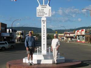
 Milepost "0"
This is where it starts.First, a little history lesson. At the outbreak of World War II there was no overland access to Alaska from the lower 48 or Canada. Fearing a Japanese invasion of Alaska (which actually did occur in June, 1942), in March 1942 the US Army undertook a crash program to build a road to supply military bases in Alaska. The road stretches 1,422 miles from Dawson Creek, BC to Delta Junction, AK, where it connects to the Richardson Highway, which runs from Valdez to Fairbanks. The project was huge, crossing rugged mountains, heavily wooded forests and swampy tundra, all under some pretty miserable weather conditions, but it was completed in eight months at a cost of $115 million, or $81,000 per mile. For comparison, the Boston Central Artery project (“the Big Dig”) cost about $1.8 billion per mile. Originally called the AlCan Highway, the road has been improved over the years, and is now paved except for a few stretches of gravel, which we are told are well maintained. However, because of upheavals caused by the extreme weather conditions, repairs and maintenance of the highway is a major ongoing project, and (as we were soon to find out) there are always stretches

 Typical highway scene in northern BC
We will see a lot of these trees by the time we reach AK.of rough road along the way.
Our first day took us to Ft. Nelson, BC traveling mainly through rolling forest country. At about mile marker 20 we spotted our first moose. We would not to see another for 1,300 miles -- past Tok, AK. On the second day the scenery got more interesting as we were in the Canadian Rockies, with lots of scenic lakes and rivers along the way. Here we saw our first caribou, bear, bison and stone sheep. We stopped for the night at Watson Lake, just over the Yukon Territory border. Watson Lake is best known for its "sign forest" started by a homesick GI working on the highway project in 1942. He posted a sign indicating the distance and direction to his home town. Others followed suit, and now there are over 60,000 signs and several thousand are being added each year. It's an eyesore, but an interesting one.
Advertisement
Tot: 0.062s; Tpl: 0.024s; cc: 13; qc: 26; dbt: 0.0231s; 1; m:domysql w:travelblog (10.17.0.13); sld: 1;
; mem: 1mb

 Milepost "0"
 Typical highway scene in northern BC


