Advertisement
Published: September 10th 2008

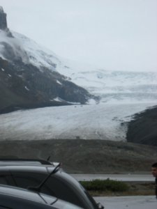
 Toe of the glacier
This is the athabasca glacier from the icefield center.Today was a big day for us! We went on a glacier hike and then came back along the icefields parkway and checked out the waterfalls along the Sunwapta and Athabasca rivers. We woke up early (for us) and drove the 1.5hrs down the Icefield Parkway to the Columbia Icefield visitor center. From this point you can see the various glaciers coming east from the columbia icefield and it's also where the large buses (called Brewsters) leave to go up onto the glacier. We did not want to do the touristy thing so we booked a guided hike/climb up onto the Athabasca glacier. This glacier retreats 100s of feet every 10 years... the center is over a mile from the ice and it is sitting at the 1902 sign post (they have signs every 10 years so you can see how far the glacier has been melting). Normal cycle or global warming? The guide gave us all a chance to give our opinions on the matter. There was a pole in the ice measuring the height of the glacier... it had melted over 15 feet in ~8 weeks.
The glacier hike was great... we climbed about 1000 vertical feet from

 Big chunk fell
This entire piece fell off the glacier the night before we were at the icefield. The ice is ~100ft tall at the break.a starting elevation of 6500ft and went about 2/3rds of the way up to the main icefall on the glacier. We saw all the main features: millwells (big vertical shafts in the ice), crevases (large cracks in the ice), and the very blue (dense) ice. A 100x350ft sized chunk of ice fell off the side of the glacier the night before we went on our hike so there was a lot of dense ice on display. Less O2 is in this ice (air bubbles) so the increased density absorbs the higher wavelengths of light (thus we only see the blue portion reflecting back at us). There were a mix of smooth stones (that are ground smooth by the ice) and sharp rocks (that ride along on top of the ice). After stepping up on the glacier, we quickly noticed how much traction we had on the ice... it has a rough texture due to the rock dust that melts down into the ice. We still put on our crampons and starting moving up the glacier. Our guide held us while we peered over into the millwell holes and crevases. Multiple streams ran on top of and under the ice so

 millwell
Here's our guide holding someone while they peer down a 40ft deep millwell. Rainwater and rocks melting through the ice form these phenomina.it was important that we had a guide to pick out a safe route. Another neat feature is looking at the glass smooth bedrock where the glacier ground it flat. As we were hanging out on the glacier it started to snow (much better than cold rain) but that quickly blew through in about 5 minutes. The ice from the icefield (that feeds the glacier) drains to all 3 oceans (Atlantic, Pacific, and Arctic)... it's the hydrographic apex of North America.
The Sunwapta and Athabasca falls were very beautiful... both were very bright blue from the glacier melt water. Greg claims that Sunwapta's lower large fall could be run in a kayak (if someone were to drop in off the cliffs surrounding the drop). The upper falls has a big rock in the middle... not very runable! The milky blue water was due to a large concerntration of glacial melt water. The green/blue waters are caused by more rainwater / snowmelt in the mix (but still with some glacial water).
During the night we hung out in the tent because it was dumping rain. Greg had the lantern going and it was nice and cozy. Around 10pm the

 we're there!
G&L up on the glacier. The straps on our feet are to hold the crampons on. It was snowing during this picture (hence the low visibility)adjacent site had some new people come in and setup their tents. Each site is only allowed 1 tent but they had 3. They also decided to chop wood starting at midnight and keep at it until about 2 a.m. Both of us were woken up and (even worse) had to get out of the tent into the cold to run to the bathroom (normally we can sleep through it and go in the morning). Quiet hours (including a fire ban) started at 11pm so there was a lot of rule breaking. We reported them the next morning but it was brushed off (perhaps friends of some of the park rangers?).
Advertisement
Tot: 0.071s; Tpl: 0.011s; cc: 9; qc: 47; dbt: 0.04s; 1; m:domysql w:travelblog (10.17.0.13); sld: 1;
; mem: 1.1mb

 Toe of the glacier
 Big chunk fell
 millwell
 we're there!


