Advertisement
Published: March 19th 2018

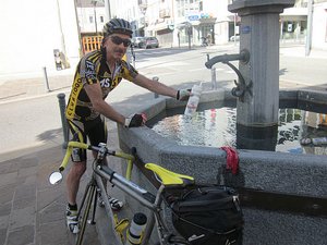
 best-water-in-town
The first of many fountain bottle-fills on this trip. There had been much discussion last night about route options for today inasmuch as we hadn't intended to be starting at such low elevation, and in the morning it was suggested we scale back our plans and climb only 2 cols, albeit both from low altitude (i.e. the river i.e. we would fully descend from the first one before attacking the second).
There were 3 roads that led from St Jean de Maurienne to the Col de Mollard (1638m), and I opted for a circular route, ascending one side of the valley and descending the other, that would bring me back into the centre of town for lunchtime.
The ascent on the 'lesser' of the two roads was beautiful, with generally a good road surface (important when descending),and I would have been happy to return along that route, but I assumed that the 'larger' road would be even better. And you know what they say about assumptions.
First I hit a gravel section before I even reached that road, but then it was only the upper section that was a bit rough, and once through the tunnels (!) the surface improved and things opened up.I was hoping for

 cols-in-every-direction
"Capitale Mondiale des Cyclo Grimpeurs" according to the poster in town.a rapid descent, but surprisingly there were even some steep uphill sections that I hadn't anticipated. Then the wind hit and I instantly lost 5kph; still, before I knew it I was back in town in the middle of the midday heat (34 degrees?) so I bought some fruit and drink, found some shade, and fueled up for the second ascent of the day - the Col Du Telegraph (1566m).
But before I got to start that endeavour I had to rejoin the same busy road that had greeted us with wind yesterday. Although the traffic had abated, the wind and temperature had increased, and we were hard-pressed to proceed even downhill. Eventually, though, our route turned, crossed the river, and started it's winding ascent. As it turned out, this was finally one climb where I didn't end up hauling a full (second) water bottle to the summit, as my main one was insufficient for the combination of grade and temperature. It was so hot, in fact, that the tar in the road was melting - which certainly didn't help things (at times it felt like riding through chewing gum).
In time, though, I was over the top
and hoping to enjoy another descent when unfortunately the air brakes again interceded. And I misread the directions about what to do in town and did some extra urban climbing, but at least I got in before the rain hit.
Now off to sleep. No time to prettify this or expand on things tonight.
Advertisement
Tot: 0.108s; Tpl: 0.011s; cc: 9; qc: 51; dbt: 0.046s; 1; m:domysql w:travelblog (10.17.0.13); sld: 1;
; mem: 1.1mb

 best-water-in-town
 cols-in-every-direction


