Singapore Geography, Singapore Geography
Advertisement
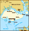
Location: Southeastern Asia, islands between Malaysia and Indonesia
Geographic coordinates: 1 22 N, 103 48 E
Map references: Southeast Asia
Area: Total: 692.7 sq km land: 682.7 sq km water: 10 sq km
Area - comparative: Slightly more than 3.5 times the size of Washington, DC
Land boundaries: 0 km
Coastline: 193 km
Maritime claims: Territorial sea: 3 nm exclusive fishing zone: within and beyond territorial sea, as defined in treaties and practice
Climate: Tropical; hot, humid, rainy; two distinct monsoon seasons - Northeastern monsoon from December to March and Southwestern monsoon from June to September; inter-monsoon - frequent afternoon and early evening thunderstorms
Terrain: Lowland; gently undulating central plateau contains water catchment area and nature preserve
Elevation extremes: Lowest point: Singapore Strait 0 m highest point: Bukit Timah 166 m
Natural resources: Fish, deepwater ports
Land use: Arable land: 1.64% permanent crops: 0% other: 98.36% (2001)
Irrigated land: NA sq km
Natural hazards: NA
Environment - current issues: Industrial pollution; limited natural fresh water resources; limited land availability presents waste disposal problems; seasonal smoke/haze resulting from forest fires in Indonesia
Environment - international agreements: Party to: Biodiversity, Climate Change, Desertification, Endangered Species, Hazardous Wastes, Law of the Sea, Ozone Layer Protection, Ship Pollution signed, but not ratified: none of the selected agreements
Geography - note: Focal point for Southeast Asian sea routes
Advertisement
The information here has been derived from Public Domain Sources such as the CIA World Factbook. No liability can be taken for any inaccuracies.
Tot: 0.021s; Tpl: 0.008s; cc: 3; qc: 2; dbt: 0.0038s; 1; m:domysql w:travelblog (10.17.0.13); sld: 1;
; mem: 1.1mb
 Singapore was founded as a British trading colony in 1819. It joined the Malaysian Federation in 1963 but separated two years later and became independent. It subsequently became one of the world's most prosperous countries with strong international ...