Advertisement
Published: December 7th 2016

 Tobelo
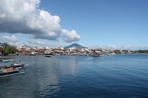
View of Tobelo from the harbourThe Sula Islands are about half-way between Ternate and Ambon, and I have been stuck on them for a week. A delightful week, but a week nonetheless. How did I end up here? Well, it all seemed rather straight forward when, after leaving Morotai and sitting in my hotel room in Tobelo on Halmahera, I realised it was time to start making my way down to Ambon… If I wanted to actually be there in time for my flight out. Make my way down to Ambon in a leisurely pace that is, with a week or so to spare on Ambon itself. I would be taking boats. There are direct boats from Ternate to Ambon, but I didn’t want to spend two and a half days on a boat. So I looked at a map.
I look at maps a lot, it is kind of an obsession really. An obsession inherited from my father, who also looked at maps a lot. I didn’t need to look at the map, I had looked at it plenty of times before and knew exactly what to expect. But looking at maps gives me a sense of satisfaction. It is a starting point, a

 Tobelo
Islands outside Tobeloplace of dreams. Maps take me away on my journey before I have even started it. They fire up my imagination about the places I am about to visit or would one day like to visit. Obscure islands, far away countries with exotic sounding names, frontier regions everybody seems to have forgotten. They catch my eye and my wandering mind. Many of my choices have been the result of map based considerations. The far north-eastern regions of India which border Myanmar? Map based! Wakhan Corridor and the Pamir’s? Map based. Qatar? Map based. Sula Islands? Map based.
Which brings us back to the Sula Islands. There is not much information out there on the Sula Islands, which of course tickled my fancy. And they were suitably located between Ternate and Ambon. I knew there were boat connections with both islands. In other words, a perfect stepping stone. A little further down is Buru Island (similarly information devoid). It, I decided, would be my second stepping stone on my journey to Ambon. I had my plan, now to execute it.
First I had to get off my ass and head towards Ternate. I went via Jailolo because I like

 Jailolo
View from the pier of my guesthouse towards the volcano outside Jailalothe way the name rolls of your tongue, Jailolo… Jailolo is a former Sultanate, the only one based on mainland Halmahera. It wasn’t very powerful, or very anything for that matter. Nowadays it is a lovely little port, beneath a volcano, with great views on Ternate and Tidore. It has a laid-back, gentle charm to it, and a sweet little guesthouse with a rear-porch overlooking the bay. From Jailolo there are jet boats to Ternate. The first part of getting to Ambon was over. Now all I needed to do was find a boat to bring me to Sula. Which I did, clearly, or else I wouldn’t be writing about Sula.
It was the fanciest boat I have taken so far in Indonesia, which isn’t saying much, because so far I have been taking rather dismal boats. No wooden platform for me this time though, with, if you are lucky, a few mattresses to sleep on... Or if you are unlucky just that hard wooden platform. I have been unlucky a few times. No, this boat had a dedicated dorm-like deck with a long row of bunk beds. Sure you are sleeping like sardines in a tin, but at

 Jailolo
Jailolo harbourleast you have a matrass! There was another more luxurious deck as well to choose from, with expensive cabins (some even air-conditioned). Of course I went sardine style. Its way more cozy. There is nothing like a sweaty fellow passenger rolling over onto your matrass in the night.
A glorious sunrise and land ahoy! There they were, the Sula Islands. Before long I was ensconced in my hotel room, the first night generously paid for by a government official I had met on the boat. The hospitality one encounters while travelling never seizes to amaze me.
The plan was to stay 3 to 4 days on the Sula Islands, then move on to Buru Island and stay 3 or 4 days there. According to my 10 year old information, there were plenty of boats between Sula and Buru. There were… none. Oops! Information was as scares on the ground as it was in cyberspace. I asked about ferries, which used to ply twice a week between the islands, at the harbour, a logical place you would think. No ferries according to them, just a passenger ship which goes directly to Ambon in a week’s time. Now, I have

 Jailolo
Bay views from the pier belonging to my guesthouselearned that no doesn’t necessarily always mean no in Indonesia, it can also mean, ‘
I don’t know, but I won’t tell you that because I will lose face if I do, so instead I will lie and tell you there aren’t any.’ It pays to keep on digging sometimes. So dig I did, with the help of my new found friends at the tourist office (yes they have one for the once yearly tourist that passes by). There was, it seemed, a separate ferry harbour. My new buddies and I went to ask the all-important question directly to the harbour master. Amazingly he didn’t actually know if or when a ferry would arrive. At least he was honest.
Ferries, it turned out, were a rather haphazard affair, with no fixed schedules and no certainties. Either one comes, or it doesn’t. In this case it never came. My digging got me nowhere, except on the passenger boat to Ambon a week later. Skipping Buru Island. C’est la vie!
Now, as I mentioned, they have a tourist office on the Sula Islands, with at least one English speaking staff member, which made my life all the easier. They were super

 Jailolo
Sunset over Tidore on the left, and Ternate on the right (the big one in the middle)friendly folk who helped me out a lot. Since I actually didn’t have a clue what there was to do on these islands, their assistance was greatly appreciated.
The Sula Island are actually three different islands, I only had time to visit the main island, Sanana Island, which isn’t the biggest, but which houses the capital of the islands, Sanana, hence the name. The biggest problem with the Sula Islands in connectivity. Both with the outside world and even between the three entities that make up the group. Public transport is abysmal, which means that to see all three islands properly you would probably need about three weeks. And they aren’t even that big!
So what is there to see on Sanana Island? Well, the main tourist attraction is probably Tanjung Waka, which is a white sandy beach with superb corals, at the far end of the island. And when I mean superb corals, I mean they were really, really good. With an abundance of fish I have rarely seen elsewhere, both big and small. And an abundance of turtles. And black tip reef sharks. And… more. Unfortunately my camera decided to play up on me exactly on

 Sula Islands
Sunrise as my boat arrives at the Sula Islandsthe day I snorkeled around those reefs, so you will just have to take my word for it. It is goooood.
You can also dive, they actually have gear, but no dive master. You won’t have to dive alone though, there is a diving club. If I had known how good it was, I would have dived instead of snorkeled. Getting to Tanjung Waka is a bit of a drag. I was lucky enough to have a car at my disposal, thanks to the tourist office, and we went with a group. Basically half of the staff decided to join in, otherwise there are pick-up trucks which ply the route once daily, which means you will have to spend the night in Tanjung Waka. There is no accommodation, so you will be sleeping with a family.
Sanana itself is a sleepy little town, with a small, old, Dutch fort, which is where the dive club keeps its gear. A little out of town is Wai Ipa, a gravel beach with a bunch of food shacks. You can snorkel there, however visibility was horrible when I went. On the other side of the island is Malbufa village which also

 Sula Islands
Village on Mangole Island, the biggest island in the Sula Island grouphas some corals, though nothing compared to Tanjung Waka. It also has a golden sandy beach, so it ain’t half bad. Then there is a Bajo village, which is interesting if you haven’t seen a Bajo village before. There are a lot of mangrove forests around the island, and it might be interesting to do some hikes in the jungle covered interior of this little island, though you will be hard pressed to find anybody who can help you with this. Finally I was told that there is good diving outside Wainin village, and around the harbour of Sanana.
And now I feel I am sounding like a travel brochure, but with so little information out there, this might help the next person who makes it to the Sula’s. Though if you decide to go to the other islands in the Sula group, you are on your own pal!
As for me, my week on the Sula’s is up. A big thank you to all the folks of the tourist office, especially Sofy, it wouldn’t have been the same without you.
Advertisement
Tot: 0.097s; Tpl: 0.014s; cc: 14; qc: 35; dbt: 0.0569s; 1; m:domysql w:travelblog (10.17.0.13); sld: 1;
; mem: 1.2mb


Jenny Adams
non-member comment
Love it
that sunset looks rad! I also love those travel moments, where you aren't stuck somewhere for hours ... but days. And you start to have that moment, where you are all "Um, have i accidentally moved here? Is it easier to just give in and live here forever than to try and ... you know ... leave now?" I'll put Sula on my list!