Togolese Geography, Togo Geography
Advertisement
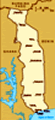
Location: Western Africa, bordering the Bight of Benin, between Benin and Ghana
Geographic coordinates: 8 00 N, 1 10 E
Map references: Africa
Area: Total: 56,785 sq km land: 54,385 sq km water: 2,400 sq km
Area - comparative: Slightly smaller than West Virginia
Land boundaries: Total: 1,647 km border countries: Benin 644 km, Burkina Faso 126 km, Ghana 877 km
Coastline: 56 km
Maritime claims: Territorial sea: 30 nm exclusive economic zone: 200 nm
Climate: Tropical; hot, humid in south; semiarid in north
Terrain: Gently rolling savanna in north; central hills; southern plateau; low coastal plain with extensive lagoons and marshes
Elevation extremes: Lowest point: Atlantic Ocean 0 m highest point: Mont Agou 986 m
Natural resources: Phosphates, limestone, marble, arable land
Land use: Arable land: 46.15% permanent crops: 2.21% other: 51.64% (2001)
Irrigated land: 70 sq km (1998 est.)
Natural hazards: Hot, dry harmattan wind can reduce visibility in north during winter; periodic droughts
Environment - current issues: Deforestation attributable to slash-and-burn agriculture and the use of wood for fuel; water pollution presents health hazards and hinders the fishing industry; air pollution increasing in urban areas
Environment - international agreements: Party to: Biodiversity, Climate Change, Climate Change-Kyoto Protocol, Desertification, Endangered Species, Law of the Sea, Ozone Layer Protection, Ship Pollution, Tropical Timber 83, Tropical Timber 94, Wetlands signed, but not ratified: none of the selected agreements
Geography - note: The country's length allows it to stretch through six distinct geographic regions; climate varies from tropical to savanna
Advertisement
The information here has been derived from Public Domain Sources such as the CIA World Factbook. No liability can be taken for any inaccuracies.
Tot: 0.041s; Tpl: 0.009s; cc: 3; qc: 2; dbt: 0.0174s; 1; m:domysql w:travelblog (10.17.0.13); sld: 1;
; mem: 1.1mb
 French Togoland became Togo in 1960. Gen. Gnassingbe EYADEMA, installed as military ruler in 1967, continued to rule well into the 21st century. Despite the facade of multiparty elections instituted in the early 1990s, the government continued to be ...