Advertisement
Published: June 17th 2017

 01 Sign
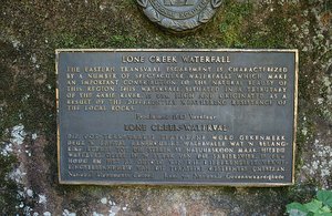
The sign at the start of the path to Lone Creek Falls.Geo: -24.7892, 30.8688
Today the four of us we went on a day trip through the scenic area of Mpumalanga. Our first stop was in the town of Sabie. Here we collected a few tourist brochures and a scenic map of the area. We continued driving towards our first scenic stop. At about a quarter past 10 we arrived at Lone Creek Falls. After paying a small entrance fee at the carpark we were allowed to continue to the waterfall.
It was a very short 200m walk along a path to the bottom of the waterfall. The waterfall was a simple, small one, just under 70m high. We were quite lucky as we were the only ones here and for the moment had the place to ourselves. The path led us to the bottom of the waterfall, after a few photos we climbed up the path to a view point. The path was quite wet and slippery in some places.
From up here we looked down at the waterfall. A rainbow had appeared in the mist of falling water. We were surrounded here by an indigenous forest. We spent about half an hour at the waterfall and then got back in the car and

 02 Path
The path that led us to the waterfall.continued our road trip.
Our next stop wasn't far away in Graskop for a little snack at Harrie's Pancakes. It is a well known cafe and we stopped for a coffee and a sweet treat. After eating too much sugar, we hit the road.
We then came across a well known lookout point, but were deterred by the price, so we went to the next lookout point which happened to be free and apparently just as scenic. This lookout point is called Wonder View and it was a wonderful view! At Wonder View there was an amazing panoramic view of the area. It is the highest view point in the area, with a height of 1730m above sea level. We spent a little bit of time here enjoying the amazing view.
Soon after we arrived at Berlin Falls. These falls were named by German miners who came to this area during the gold rush and named it after their country's capital city. The walk to the falls is very easy and we only viewed it from the top. We didn't stay here for long.
After another short amount of driving we stopped again. This time we were at Lowveld View. We had now

 04 Waterfall
The Lone Creek Falls as seen from the base of the waterfall.entered the Blyde River Canyon Nature Reserve. We spent quite a while at the lookout and took many photos as we enjoyed the scenery and its serenity.
We were now coming to the last few stops of the day. A few kilometres from the Lowveld View we came to the last stop in the Blyde River Canyon Nature Reserve. This place had the best view of the canyon and the famous Three Rondavels. This red sandstone rock formation is also known as the Three Sisters. There was a path here that we walked along. Along the way we took many photos and had to battle with crowds! This was the busiest place that we have been to today.This canyon is the second largest canyon in Africa and the greenest canyon in the world.
Our day was now nearly over, except for one more stop that Paul and his dad were desperate for us to make. It was in the hope of seeing a pair of Taita Falcons. They are both keen birders and this is one of the few places to see these birds in South Africa. We drove along the Abel Erasmus Pass and had our eyes peeled for the

 05 Waterfall
The Lone Creek Falls as seen from the base of the waterfall.place to stop to see these birds.
We saw the place, there was a little bit of space for a few cars and some roadside stalls selling curios. We got out and were approached by Michael, the local Taita Falcon guide. He told us that he hadn't seen the birds for a while, but with his binoculars he looked around. Michael pointed out to us where their nest is.
As we waited we did see some other birds. The guide also gave us lots of information about the Taita Falcon and the other birds in the area. We had been here for about half an hour and it was now time to leave. There was a long drive ahead of us and we didn't want to be driving around after sunset. We thanked him and started driving back to Nelspruit.
Tonight's dinner was a simple one, take away pizza which we ate on the deck of the BnB with some wine.
Advertisement
Tot: 0.101s; Tpl: 0.013s; cc: 11; qc: 29; dbt: 0.0431s; 1; m:domysql w:travelblog (10.17.0.13); sld: 1;
; mem: 1.1mb


