Advertisement
Published: December 8th 2020

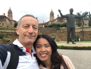
 Union Buildings
Seat of Government and PresidentEarly dawn we drove to Pretoria about 50 km North of Johannesburg. Pretoria, is one of the three capital cities in modern South Africa. The other two are Bloemfontein and Cape Town. Pretoria was founded in 1855 by the Boer leader Marthinus Pretorius, (his people also called Voortrekkers) and named it after his father, Andries Pretorius. Pretorius father had become a national hero of the Voortrekkers after his victory over king Dingane and the Zulu Africans in the Battle of Blood River in 1838. They founded the Transvaal Republic with Pretoria as its capital. After the discovery of diamonds and gold in the Boers areas the British Empire annexed the territories they earlier agreed to assign to them, leading to the Boer Wars. The lost war resulted in the end of the Transvaal Boer Republic and the start of the British hegemony in South Africa. Pretoria surrendered to British forces in 1900, with the signing of the Peace of Vereeniging on 31 May 1902. The Pretoria Forts were built for the defense of the city just prior to the Second Boer War, some of them preserved today as national monuments, most of them destroyed.
Pretoria is situated between the plateau
of the 'Highveld' to the south and the lower-lying 'Bushveld' to the north. It lies at an altitude of about 1,400 m above sea level, in a warm, sheltered, fertile valley, surrounded by the hills of the Magaliesberg range and has a rather humid sub tropical climate. The city has 700,000 inhabitants. Afrikaans is the largest ethnic group in the city, unusual for South Africa of today. Even after the Apartheid the predominantly 'white' appearance is maintained. Pretoria is known as the "Jacaranda City" due to the approximately 50,000 Jacarandas that line its streets. Purple is a color often associated with the city.
Nicole, who grew up here gave us a little tour. Voortrekker Monument (a quite Nationalistically Afrikaans drawn up historical site, yet worth visiting), the Union Buildings and the story of Stephanus Johannes Paulus "Paul" Kruger a South African politician of Boer origin. He was one of the dominant political and military figures in 19th-century South Africa, and President of the South African Transvaal Republic from 1883 to 1900. The other story was of Piet Retief (Pieter Mauritz Retief 1780–1838) a Voortrekker leader who was a key figure during their Great Trek. The cities of Pietermaritzburg and
Piet Retief were named in his honor. The massacre of Retief and his Voortecker group by the Zulu King Dingane and the extermination of several Voortrekker laagercamps in the area, led to the Battle of Blood River on 16 December 1838. The Afrikaans community till today celebrates this victory with patriotic gatherings on Dec 16. The new ANC (African National Congress) Government dominated by the Zulus has cancelled this previously declared public holiday, despising this memorial day.
To reach our destination of Day 2 we needed to drive to Hazyview, a town of 5,000 inhabitants 380 km to the North East. We crossed from Guateng into the province of Mpumalanga in Zulu language meaning "the place where the sun rises". Bordering the nations of Swaziland and Mozambique it embraces the southern half of Kruger National Park, a huge nature reserve with abundant wildlife including big game. A place we will go in a couple of days as well. For now we are steering our Nissan through the high plateau grasslands of the Middleveld and towards the mountains of the Drakensberg Escarpment. Famous for its numerous waterfalls this Escarpment plunges hundreds of meters down into the low-lying area known as
the Lowveld. Passing the towns of Dullstroom (the trout capital of South Africa, a must stop for lunch), Lydenburch (known for its fly-fishing industry today, for its gold fields and the Boer Wars in the past), the Misty Mountains (where you can find the highest micro brewery of Africa on 2100 m altitude) and Sabie (a forestry town situated on the banks of the Sabie River. The name Sabie is derived from the Tsonga word "Ulusaba" which means "fearful river" because the river was once teeming with dangerous Nile crocodile). Our accommodation was charming but had a quite run down infrastructure. Never mind it 's part of travelling. Tomorrow a real treat is awaiting us the Panorama Route with its wonderful canyons and waterfalls.
Advertisement
Tot: 0.069s; Tpl: 0.013s; cc: 10; qc: 27; dbt: 0.0314s; 1; m:domysql w:travelblog (10.17.0.13); sld: 1;
; mem: 1.1mb

 Union Buildings
 visiting dignitaries


