Advertisement
Published: March 9th 2020

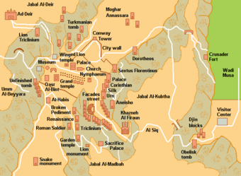
 Map of Petra
The beginning is on the right, the Treasury is #4, the theater is #7, down the Collonade to #13, then a donkey ride up to #15 the Monastery.At last - Petra! Egypt Pyramids and Jordan Petra are the reasons why I picked this trip. I am looking forward to Israel as well, but right now I'm immersed in Jordan sights.
Yesterday when we drove here it seems like we went quickly from the green north part of Jordan to the desert. The area around Petra is near the major trade and caravan routes between Egypt and Syria/Turkey/Armenia/Iran. The area is so rocky and it's difficult for me to see how there were trade routes through here.
We got up early, had a 5 a.m. breakfast, left at 6 a.m. and were one of the first to arrive. This gave us the benefit of an uncrowded place and not in the heat of the day, Talal, our leader took us from #1 to #13 on the map and we had till 2 p.m. to explore. I had fallen in the beginning of the hike (my left ankle slipped and I fell to the right banging & scraping my right knee) and took a donkey ride up to the Monastery (there are supposedly 900 steps to get there). He didn't actually bring me to the top - there
The beginning
My left foot slipped in the ditch and I fell to the right. is a place where the donkey's can't go further and I walked another 20 minutes to the top. The Monastery is huge. It's hard to believe they built it way up near the top of this rocky gorge. To me it's just as majestic as the Treasury, which is the one everyone sees in pictures.
I hike past the Monastery to a view point of a very rocky terrain. I forgot to mention that you can shop the whole way up, and there are cafes along the way. It seems like a pilgrimage thing to do to hike up to the Monastery because loads of people do it. I saw the rest of my group and started down. I did some shopping on the way and finally got to the visitor center. The heat really bothered me and I was glad to get back to the hotel.
Some people in our group got a Turkish Hammam - the scrub/massage. We all went out to dinner together and most of the group went to Petra at Night. I didn't go because my knee hurts (the donkey actually got too close to the rock and my knee got slammed on
the rock).
Petra (
Arabic: ٱلْبَتْرَاء,
romanized: Al-Batrāʾ;
Ancient Greek: Πέτρα, "Stone"), originally known to its inhabitants as
Raqmu,
is a historical and archaeological city in southern
Jordan. Petra lies around
Jabal Al-Madbah in a
basin surrounded by mountains which form the eastern flank of the
Arabah valley that runs from the
Dead Sea to the
Gulf of Aqaba.
The area around Petra has been inhabited as early as 7,000 BC,
and the
Nabataeans might have settled in what would become the capital city of their
kingdom, as early as the 4th century BC.
However, archaeological work has only discovered evidence of Nabataean presence dating back to the second century BC,
by which time Petra had become their capital.
The Nabataeans were nomadic
Arabs who invested in Petra's proximity to the
trade routes by establishing it as a major regional trading hub.
The trading business gained the Nabataeans considerable revenue and Petra became the focus of their wealth. The Nabataeans were accustomed to living in the barren deserts, unlike their enemies, and were able to repel attacks by taking advantage of the area's mountainous terrain. They
were particularly skillful in
harvesting rainwater,
agriculture and
stone carving. Petra flourished in the 1st century AD, when its famous
Khazneh structure – believed to be the
mausoleum of Nabataean king
Aretas IV – was constructed, and its population peaked at an estimated 20,000 inhabitants.
Although the Nabataean kingdom became a client state of the
Roman Empire in the first century BC, it was only in 106 AD that it lost its independence. Petra fell to the Romans, who annexed Nabataea and renamed it as
Arabia Petraea. Petra's importance declined as sea trade routes emerged, and after an
earthquake in 363 destroyed many structures. In the
Byzantine era several Christian churches were built, but the city continued to decline, and by the early Islamic era it was abandoned except for a handful of nomads. It remained unknown to the world until it was rediscovered in 1812 by
Johann Ludwig Burckhardt.
Access to the city is through a 1.2-kilometre-long (0.75 mi) gorge called the
Siq, which leads directly to the Khazneh. Famous for its
rock-cut architecture and water conduit system, Petra is also called the 'Rose City' because of the colour of the stone from which it is carved.
It has been a
UNESCO World Heritage Site since 1985. UNESCO has described Petra as "one of the most precious cultural properties of man's cultural heritage".
In 2007, Al-Khazneh was voted one of the
New7Wonders of the World. Petra is a symbol of Jordan, as well as Jordan's most-visited tourist attraction. Tourist numbers peaked at 918,000 in 2010, but there followed a temporary slump during the political instability generated by the
Arab Spring, which affected countries surrounding Jordan.
Visitor numbers subsequently increased and reached a record-breaking 1.1 million tourists in 2019, marking the first time that the figure rose above the 1 million mark.
Water control
Excavations have demonstrated that it was the ability of the Nabataeans to control the water supply that led to the rise of the desert city, creating an artificial
oasis. The area is visited by
flash floods, but archaeological evidence shows that the Nabataeans controlled these floods by the use of
dams,
cisterns and water conduits. These innovations stored water for prolonged periods of
drought and enabled the city to prosper from its sale.
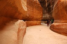
The narrow passage (
Siq) that leads to Petra
Access routes
In ancient times, Petra might have been approached from
the south on a track leading across the plain of Petra, around Jabal Haroun ("Aaron's Mountain"), the location of the
Tomb of Aaron, said to be the burial place of
Aaron, brother of
Moses. Another approach was possibly from the high plateau to the north. Today, most modern visitors approach the site from the east. The impressive eastern entrance leads steeply down through a dark, narrow gorge, in places only 3–4 m (10–13 ft) wide, called the
Siq ("shaft"), a natural geological feature formed from a deep split in the
sandstone rocks and serving as a waterway flowing into
Wadi Musa.
City centre
At the end of the narrow gorge, the Siq, stands Petra's most elaborate ruin, popularly known as
Al Khazneh ("the Treasury"), hewn into the sandstone cliff. While remaining in remarkably preserved condition, the face of the structure is marked by hundreds of bullet holes made by the local Bedouin tribes that hoped to dislodge riches that were once rumoured to be hidden within it.
A little further from the Treasury, at the foot of the mountain called
en-Nejr, is a massive
theatre, positioned so as to bring the greatest number of
tombs within view. At
the point where the valley opens out into the plain, the site of the city is revealed with striking effect. The theatre has been cut into the hillside and into several of the tombs during its construction. Rectangular gaps in the seating are still visible. Almost enclosing it on three sides are rose-coloured mountain walls, divided into groups by deep fissures and lined with knobs cut from the rock in the form of towers.
The Monastery, Petra's largest monument, dates from the 1st century BC. It was dedicated to Obodas I and is believed to be the symposium of Obodas the god. This information is inscribed on the ruins of the Monastery (the name is the translation of the Arabic "
Ad Deir").
Advertisement
Tot: 0.11s; Tpl: 0.017s; cc: 12; qc: 29; dbt: 0.0347s; 1; m:domysql w:travelblog (10.17.0.13); sld: 1;
; mem: 1.2mb


 Maroon


