Aruban; Dutch Geography, Aruba Geography
Advertisement
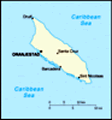
Location: Caribbean, island in the Caribbean Sea, north of Venezuela
Geographic coordinates: 12 30 N, 69 58 W
Map references: Central America and the Caribbean
Area: Total: 193 sq km land: 193 sq km water: 0 sq km
Area - comparative: Slightly larger than Washington, DC
Land boundaries: 0 km
Coastline: 68.5 km
Maritime claims: Territorial sea: 12 nm
Climate: Tropical marine; little seasonal temperature variation
Terrain: Flat with a few hills; scant vegetation
Elevation extremes: Lowest point: Caribbean Sea 0 m highest point: Mount Jamanota 188 m
Natural resources: NEGL; white sandy beaches
Land use: Arable land: 10.53% (including aloe 0.01%) permanent crops: 0% other: 89.47% (2001)
Irrigated land: 0.01 sq km (1998 est.)
Natural hazards: Lies outside the Caribbean hurricane belt
Environment - current issues: NA
Environment - international agreements:
Geography - note: A flat, riverless island renowned for its white sand beaches; its tropical climate is moderated by constant trade winds from the Atlantic Ocean; the temperature is almost constant at about 27 degrees Celsius (81 degrees Fahrenheit)
Advertisement
The information here has been derived from Public Domain Sources such as the CIA World Factbook. No liability can be taken for any inaccuracies.
Tot: 0.033s; Tpl: 0.007s; cc: 6; qc: 6; dbt: 0.0088s; 1; m:domysql w:travelblog (10.17.0.13); sld: 1;
; mem: 1.1mb
 Discovered and claimed for Spain in 1499, Aruba was acquired by the Dutch in 1636. The island's economy has been dominated by three main industries. A 19th century gold rush was followed by prosperity brought on by the opening in 1924 of an oil refin...