Venezuelan Geography, Venezuela Geography
Advertisement
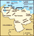
Location: Northern South America, bordering the Caribbean Sea and the North Atlantic Ocean, between Colombia and Guyana
Geographic coordinates: 8 00 N, 66 00 W
Map references: South America
Area: Total: 912,050 sq km land: 882,050 sq km water: 30,000 sq km
Area - comparative: Slightly more than twice the size of California
Land boundaries: Total: 4,993 km border countries: Brazil 2,200 km, Colombia 2,050 km, Guyana 743 km
Coastline: 2,800 km
Maritime claims: Territorial sea: 12 nm contiguous zone: 15 nm exclusive economic zone: 200 nm continental shelf: 200-m depth or to the depth of exploitation
Climate: Tropical; hot, humid; more moderate in highlands
Terrain: Andes Mountains and Maracaibo Lowlands in northwest; central plains (llanos); Guiana Highlands in southeast
Elevation extremes: Lowest point: Caribbean Sea 0 m highest point: Pico Bolivar (La Columna) 5,007 m
Natural resources: Petroleum, natural gas, iron ore, gold, bauxite, other minerals, hydropower, diamonds
Land use: Arable land: 2.95% permanent crops: 0.92% other: 96.13% (2001)
Irrigated land: 540 sq km (1998 est.)
Natural hazards: Subject to floods, rockslides, mudslides; periodic droughts
Environment - current issues: Sewage pollution of Lago de Valencia; oil and urban pollution of Lago de Maracaibo; deforestation; soil degradation; urban and industrial pollution, especially along the Caribbean coast; threat to the rainforest ecosystem from irresponsible mining operations
Environment - international agreements: Party to: Antarctic Treaty, Biodiversity, Climate Change, Desertification, Endangered Species, Hazardous Wastes, Marine Life Conservation, Ozone Layer Protection, Ship Pollution, Tropical Timber 83, Tropical Timber 94, Wetlands
Geography - note: On major sea and air routes linking North and South America; Angel Falls in the Guiana Highlands is the world's highest waterfall
Advertisement
The information here has been derived from Public Domain Sources such as the CIA World Factbook. No liability can be taken for any inaccuracies.
Tot: 0.023s; Tpl: 0.008s; cc: 2; qc: 3; dbt: 0.0058s; 1; m:domysql w:travelblog (10.17.0.13); sld: 1;
; mem: 1mb
 Venezuela was one of three countries that emerged from the collapse of Gran Colombia in 1830 (the others being Colombia and Ecuador). For most of the first half of the 20th century, Venezuela was ruled by generally benevolent military strongmen, who ...