Bolivian Geography, Bolivia Geography
Advertisement
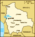
Location: Central South America, southwest of Brazil
Geographic coordinates: 17 00 S, 65 00 W
Map references: South America
Area: Total: 1,098,580 sq km land: 1,084,390 sq km water: 14,190 sq km
Area - comparative: Slightly less than three times the size of Montana
Land boundaries: Total: 6,743 km border countries: Argentina 832 km, Brazil 3,400 km, Chile 861 km, Paraguay 750 km, Peru 900 km
Coastline: 0 km (landlocked)
Maritime claims: None (landlocked)
Climate: Varies with altitude; humid and tropical to cold and semiarid
Terrain: Rugged Andes Mountains with a highland plateau (Altiplano), hills, lowland plains of the Amazon Basin
Elevation extremes: Lowest point: Rio Paraguay 90 m highest point: Nevado Sajama 6,542 m
Natural resources: Tin, natural gas, petroleum, zinc, tungsten, antimony, silver, iron, lead, gold, timber, hydropower
Land use: Arable land: 2.67% permanent crops: 0.19% other: 97.14% (2001)
Irrigated land: 1,280 sq km (1998 est.)
Natural hazards: Flooding in the northeast (March-April)
Environment - current issues: The clearing of land for agricultural purposes and the international demand for tropical timber are contributing to deforestation; soil erosion from overgrazing and poor cultivation methods (including slash-and-burn agriculture); desertification; loss of biodiversity; industrial pollution of water supplies used for drinking and irrigation
Environment - international agreements: Party to: Biodiversity, Climate Change, Climate Change-Kyoto Protocol, Desertification, Endangered Species, Hazardous Wastes, Law of the Sea, Marine Dumping, Ozone Layer Protection, Ship Pollution, Tropical Timber 83, Tropical Timber 94, Wetlands signed, but not ratified: Environmental Modification, Marine Life Conservation, Ozone Layer Protection
Geography - note: Landlocked; shares control of Lago Titicaca, world's highest navigable lake (elevation 3,805 m), with Peru
Advertisement
The information here has been derived from Public Domain Sources such as the CIA World Factbook. No liability can be taken for any inaccuracies.
Tot: 0.023s; Tpl: 0.007s; cc: 3; qc: 2; dbt: 0.0054s; 1; m:domysql w:travelblog (10.17.0.13); sld: 1;
; mem: 1mb
 Bolivia, named after independence fighter Simon BOLIVAR, broke away from Spanish rule in 1825; much of its subsequent history has consisted of a series of nearly 200 coups and counter-coups. Comparatively democratic civilian rule was established in 1...