Israeli Geography, Israel Geography
Advertisement
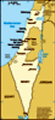
Location: Middle East, bordering the Mediterranean Sea, between Egypt and Lebanon
Geographic coordinates: 31 30 N, 34 45 E
Map references: Middle East
Area: Total: 20,770 sq km land: 20,330 sq km water: 440 sq km
Area - comparative: Slightly smaller than New Jersey
Land boundaries: Total: 1,017 km border countries: Egypt 266 km, Gaza Strip 51 km, Jordan 238 km, Lebanon 79 km, Syria 76 km, West Bank 307 km
Coastline: 273 km
Maritime claims: Territorial sea: 12 nm continental shelf: to depth of exploitation
Climate: Temperate; hot and dry in southern and eastern desert areas
Terrain: Negev desert in the south; low coastal plain; central mountains; Jordan Rift Valley
Elevation extremes: Lowest point: Dead Sea -408 m highest point: Har Meron 1,208 m
Natural resources: Timber, potash, copper ore, natural gas, phosphate rock, magnesium bromide, clays, sand
Land use: Arable land: 16.39% permanent crops: 4.17% other: 79.44% (2001)
Irrigated land: 1,990 sq km (1998 est.)
Natural hazards: Sandstorms may occur during spring and summer; droughts; periodic earthquakes
Environment - current issues: Limited arable land and natural fresh water resources pose serious constraints; desertification; air pollution from industrial and vehicle emissions; groundwater pollution from industrial and domestic waste, chemical fertilizers, and pesticides
Environment - international agreements: Party to: Biodiversity, Climate Change, Climate Change-Kyoto Protocol, Desertification, Endangered Species, Hazardous Wastes, Ozone Layer Protection, Ship Pollution, Wetlands signed, but not ratified: Marine Life Conservation
Geography - note: There are 242 Israeli settlements and civilian land use sites in the West Bank, 42 in the Israeli-occupied Golan Heights, 25 in the Gaza Strip, and 29 in East Jerusalem (February 2002 est.); Sea of Galilee is an important freshwater source
Advertisement
The information here has been derived from Public Domain Sources such as the CIA World Factbook. No liability can be taken for any inaccuracies.
Tot: 0.021s; Tpl: 0.007s; cc: 3; qc: 4; dbt: 0.0047s; 1; m:domysql w:travelblog (10.17.0.13); sld: 1;
; mem: 1mb
 Following World War II, the British withdrew from their mandate of Palestine, and the UN partitioned the area into Arab and Jewish states, an arrangement rejected by the Arabs. Subsequently, the Israelis defeated the Arabs in a series of wars without...