none Geography, Vatican City Geography
Advertisement
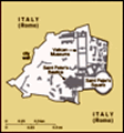
Location: Southern Europe, an enclave of Rome (Italy)
Geographic coordinates: 41 54 N, 12 27 E
Map references: Europe
Area: Total: 0.44 sq km land: 0.44 sq km water: 0 sq km
Area - comparative: About 0.7 times the size of The Mall in Washington, DC
Land boundaries: Total: 3.2 km border countries: Italy 3.2 km
Coastline: 0 km (landlocked)
Maritime claims: None (landlocked)
Climate: Temperate; mild, rainy winters (September to mid-May) with hot, dry summers (May to September)
Terrain: Low hill
Elevation extremes: Lowest point: unnamed location 19 m highest point: unnamed location 75 m
Natural resources: None
Land use: Arable land: 0% permanent crops: 0% other: 100% (urban area) (2001)
Irrigated land: 0 sq km (1998 est.)
Natural hazards: NA
Environment - current issues: NA
Environment - international agreements: Party to: none of the selected agreements signed, but not ratified: Air Pollution, Environmental Modification
Geography - note: Urban; landlocked; enclave in Rome, Italy; world's smallest state; outside the Vatican City, 13 buildings in Rome and Castel Gandolfo (the pope's summer residence) enjoy extraterritorial rights
Advertisement
The information here has been derived from Public Domain Sources such as the CIA World Factbook. No liability can be taken for any inaccuracies.
Tot: 0.022s; Tpl: 0.007s; cc: 3; qc: 2; dbt: 0.0043s; 1; m:domysql w:travelblog (10.17.0.13); sld: 1;
; mem: 1.1mb
 Popes in their secular role ruled portions of the Italian peninsula for more than a thousand years until the mid 19th century, when many of the Papal States were seized by the newly united Kingdom of Italy. In 1870, the pope's holdings were further c...