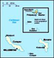
Map of Netherlands Antilles
Advertisement

Map of Netherlands Antilles
: Caribbean, two island groups in the Caribbean Sea - composed of five islands, Curacao and Bonaire located off the coast of Venezuela, and St. Maarten, Saba, and St. Eustatius lie east of the US Virgin Islands
Advertisement
The information here has been derived from Public Domain Sources such as the CIA World Factbook. No liability can be taken for any inaccuracies.
Tot: 0.042s; Tpl: 0.016s; cc: 3; qc: 11; dbt: 0.0077s; 1; m:domysql w:travelblog (10.17.0.13); sld: 1;
; mem: 1.1mb
 Once the center of the Caribbean slave trade, the island of Curacao was hard hit by the abolition of slavery in 1863. Its prosperity (and that of neighboring Aruba) was restored in the early 20th century with the construction of oil refineries to ser...