Dutch Antillean Geography, Netherlands Antilles Geography
Advertisement
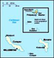
Location: Caribbean, two island groups in the Caribbean Sea - composed of five islands, Curacao and Bonaire located off the coast of Venezuela, and St. Maarten, Saba, and St. Eustatius lie east of the US Virgin Islands
Geographic coordinates: 12 15 N, 68 45 W
Map references: Central America and the Caribbean
Area: Total: 960 sq km land: 960 sq km water: 0 sq km note: includes Bonaire, Curacao, Saba, Sint Eustatius, and Sint Maarten (Dutch part of the island of Saint Martin)
Area - comparative: More than five times the size of Washington, DC
Land boundaries: Total: 10.2 km border countries: Guadeloupe (Saint-Martin) 10.2 km
Coastline: 364 km
Maritime claims: Territorial sea: 12 nm exclusive fishing zone: 12 nm
Climate: Tropical; ameliorated by northeast trade winds
Terrain: Generally hilly, volcanic interiors
Elevation extremes: Lowest point: Caribbean Sea 0 m highest point: Mount Scenery 862 m
Natural resources: Phosphates (Curacao only), salt (Bonaire only)
Land use: Arable land: 10% permanent crops: 0% other: 90% (2001)
Irrigated land: NA sq km
Natural hazards: Curacao and Bonaire are south of Caribbean hurricane belt and are rarely threatened; Sint Maarten, Saba, and Sint Eustatius are subject to hurricanes from July to October
Environment - current issues: NA
Environment - international agreements:
Geography - note: The five islands of the Netherlands Antilles are divided geographically into the Leeward Islands (northern) group (Saba, Sint Eustatius, and Sint Maarten) and the Windward Islands (southern) group (Bonaire and Curacao)
Advertisement
The information here has been derived from Public Domain Sources such as the CIA World Factbook. No liability can be taken for any inaccuracies.
Tot: 0.031s; Tpl: 0.008s; cc: 2; qc: 4; dbt: 0.0092s; 1; m:domysql w:travelblog (10.17.0.13); sld: 1;
; mem: 1.1mb
 Once the center of the Caribbean slave trade, the island of Curacao was hard hit by the abolition of slavery in 1863. Its prosperity (and that of neighboring Aruba) was restored in the early 20th century with the construction of oil refineries to ser...