Bahamian Geography, Bahamas Geography
Advertisement
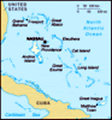
Location: Caribbean, chain of islands in the North Atlantic Ocean, southeast of Florida, northeast of Cuba
Geographic coordinates: 24 15 N, 76 00 W
Map references: Central America and the Caribbean
Area: Total: 13,940 sq km land: 10,070 sq km water: 3,870 sq km
Area - comparative: Slightly smaller than Connecticut
Land boundaries: 0 km
Coastline: 3,542 km
Maritime claims: Territorial sea: 12 nm exclusive economic zone: 200 nm
Climate: Tropical marine; moderated by warm waters of Gulf Stream
Terrain: Long, flat coral formations with some low rounded hills
Elevation extremes: Lowest point: Atlantic Ocean 0 m highest point: Mount Alvernia, on Cat Island 63 m
Natural resources: Salt, aragonite, timber, arable land
Land use: Arable land: 0.8% permanent crops: 0.4% other: 98.8% (2001)
Irrigated land: NA
Natural hazards: Hurricanes and other tropical storms cause extensive flood and wind damage
Environment - current issues: Coral reef decay; solid waste disposal
Environment - international agreements: Party to: Biodiversity, Climate Change, Climate Change-Kyoto Protocol, Desertification, Endangered Species, Hazardous Wastes, Law of the Sea, Ozone Layer Protection, Ship Pollution, Wetlands signed, but not ratified: none of the selected agreements
Geography - note: Strategic location adjacent to US and Cuba; extensive island chain of which 30 are inhabited
Advertisement
The information here has been derived from Public Domain Sources such as the CIA World Factbook. No liability can be taken for any inaccuracies.
Tot: 0.022s; Tpl: 0.008s; cc: 3; qc: 2; dbt: 0.0041s; 1; m:domysql w:travelblog (10.17.0.13); sld: 1;
; mem: 1.1mb
 Arawak Indians inhabited the islands when Christopher Columbus first set foot in the New World on San Salvador in 1492. British settlement of the islands began in 1647; the islands became a colony in 1783. Since attaining independence from the UK in ...