Swazi Geography, Swaziland Geography
Advertisement
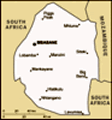
Location: Southern Africa, between Mozambique and South Africa
Geographic coordinates: 26 30 S, 31 30 E
Map references: Africa
Area: Total: 17,363 sq km land: 17,203 sq km water: 160 sq km
Area - comparative: Slightly smaller than New Jersey
Land boundaries: Total: 535 km border countries: Mozambique 105 km, South Africa 430 km
Coastline: 0 km (landlocked)
Maritime claims: None (landlocked)
Climate: Varies from tropical to near temperate
Terrain: Mostly mountains and hills; some moderately sloping plains
Elevation extremes: Lowest point: Great Usutu River 21 m highest point: Emlembe 1,862 m
Natural resources: Asbestos, coal, clay, cassiterite, hydropower, forests, small gold and diamond deposits, quarry stone, and talc
Land use: Arable land: 10.35% permanent crops: 0.7% other: 88.95% (2001)
Irrigated land: 690 sq km (1998 est.)
Natural hazards: Drought
Environment - current issues: Limited supplies of potable water; wildlife populations being depleted because of excessive hunting; overgrazing; soil degradation; soil erosion
Environment - international agreements: Party to: Biodiversity, Climate Change, Desertification, Endangered Species, Ozone Layer Protection signed, but not ratified: Law of the Sea
Geography - note: Landlocked; almost completely surrounded by South Africa
Advertisement
The information here has been derived from Public Domain Sources such as the CIA World Factbook. No liability can be taken for any inaccuracies.
Tot: 0.026s; Tpl: 0.008s; cc: 3; qc: 2; dbt: 0.0052s; 1; m:domysql w:travelblog (10.17.0.13); sld: 1;
; mem: 1.1mb
 Autonomy for the Swazis of southern Africa was guaranteed by the British in the late 19th century; independence was granted in 1968. Student and labor unrest during the 1990s pressured the monarchy (one of the oldest on the continent) to grudgingly a...