Malawian Geography, Malawi Geography
Advertisement
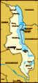
Location: Southern Africa, east of Zambia
Geographic coordinates: 13 30 S, 34 00 E
Map references: Africa
Area: Total: 118,480 sq km land: 94,080 sq km water: 24,400 sq km
Area - comparative: Slightly smaller than Pennsylvania
Land boundaries: Total: 2,881 km border countries: Mozambique 1,569 km, Tanzania 475 km, Zambia 837 km
Coastline: 0 km (landlocked)
Maritime claims: None (landlocked)
Climate: Sub-tropical; rainy season (November to May); dry season (May to November)
Terrain: Narrow elongated plateau with rolling plains, rounded hills, some mountains
Elevation extremes: Lowest point: junction of the Shire River and international boundary with Mozambique 37 m highest point: Sapitwa (Mount Mlanje) 3,002 m
Natural resources: Limestone, arable land, hydropower, unexploited deposits of uranium, coal, and bauxite
Land use: Arable land: 23.38% permanent crops: 1.49% other: 75.13% (2001)
Irrigated land: 280 sq km (1998 est.)
Natural hazards: NA
Environment - current issues: Deforestation; land degradation; water pollution from agricultural runoff, sewage, industrial wastes; siltation of spawning grounds endangers fish populations
Environment - international agreements: Party to: Biodiversity, Climate Change, Climate Change-Kyoto Protocol, Desertification, Endangered Species, Environmental Modification, Hazardous Wastes, Marine Life Conservation, Ozone Layer Protection, Ship Pollution, Wetlands signed, but not ratified: Law of the Sea
Geography - note: Landlocked; Lake Nyasa, some 580 km long, is the country's most prominent physical feature
Advertisement
The information here has been derived from Public Domain Sources such as the CIA World Factbook. No liability can be taken for any inaccuracies.
Tot: 0.032s; Tpl: 0.007s; cc: 3; qc: 2; dbt: 0.0051s; 1; m:domysql w:travelblog (10.17.0.13); sld: 1;
; mem: 1.1mb
 Established in 1891, the British protectorate of Nyasaland became the independent nation of Malawi in 1964. After three decades of one-party rule under President Hastings Kamuzu BANDA the country held multiparty elections in 1994, under a provisional...