Gambian Geography, Gambia Geography
Advertisement
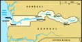
Location: Western Africa, bordering the North Atlantic Ocean and Senegal
Geographic coordinates: 13 28 N, 16 34 W
Map references: Africa
Area: Total: 11,300 sq km land: 10,000 sq km water: 1,300 sq km
Area - comparative: Slightly less than twice the size of Delaware
Land boundaries: Total: 740 km border countries: Senegal 740 km
Coastline: 80 km
Maritime claims: Territorial sea: 12 nm contiguous zone: 18 nm continental shelf: not specified exclusive fishing zone: 200 nm
Climate: Tropical; hot, rainy season (June to November); cooler, dry season (November to May)
Terrain: Flood plain of the Gambia River flanked by some low hills
Elevation extremes: Lowest point: Atlantic Ocean 0 m highest point: unnamed location 53 m
Natural resources: Fish, titanium (rutile and ilmenite), tin, zircon, silica sand, clay, petroleum
Land use: Arable land: 25% permanent crops: 0.5% other: 74.5% (2001)
Irrigated land: 20 sq km (1998 est.)
Natural hazards: Drought (rainfall has dropped by 30% in the last 30 years)
Environment - current issues: Deforestation; desertification; water-borne diseases prevalent
Environment - international agreements: Party to: Biodiversity, Climate Change, Climate Change-Kyoto Protocol, Desertification, Endangered Species, Hazardous Wastes, Law of the Sea, Ozone Layer Protection, Ship Pollution, Wetlands signed, but not ratified: none of the selected agreements
Geography - note: Almost an enclave of Senegal; smallest country on the continent of Africa
Advertisement
The information here has been derived from Public Domain Sources such as the CIA World Factbook. No liability can be taken for any inaccuracies.
Tot: 0.033s; Tpl: 0.007s; cc: 5; qc: 8; dbt: 0.0084s; 1; m:domysql w:travelblog (10.17.0.13); sld: 1;
; mem: 1.1mb
 The Gambia gained its independence from the UK in 1965; it formed a short-lived federation of Senegambia with Senegal between 1982 and 1989. In 1991 the two nations signed a friendship and cooperation treaty. A military coup in 1994 overthrew the pre...