Burundian Geography, Burundi Geography
Advertisement
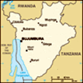
Location: Central Africa, east of Democratic Republic of the Congo
Geographic coordinates: 3 30 S, 30 00 E
Map references: Africa
Area: Total: 27,830 sq km land: 25,650 sq km water: 2,180 sq km
Area - comparative: Slightly smaller than Maryland
Land boundaries: Total: 974 km border countries: Democratic Republic of the Congo 233 km, Rwanda 290 km, Tanzania 451 km
Coastline: 0 km (landlocked)
Maritime claims: None (landlocked)
Climate: Equatorial; high plateau with considerable altitude variation (772 m to 2,670 m above sea level); average annual temperature varies with altitude from 23 to 17 degrees centigrade but is generally moderate as the average altitude is about 1,700 m; average annual rainfall is about 150 cm; wet seasons from February to May and September to November, and dry seasons from June to August and December to January
Terrain: Hilly and mountainous, dropping to a plateau in east, some plains
Elevation extremes: Lowest point: Lake Tanganyika 772 m highest point: Heha 2,670 m
Natural resources: Nickel, uranium, rare earth oxides, peat, cobalt, copper, platinum, vanadium, arable land, hydropower, niobium, tantalum, gold, tin, tungsten, kaolin, limestone
Land use: Arable land: 35.05% permanent crops: 14.02% other: 50.93% (2001)
Irrigated land: 740 sq km (1998 est.)
Natural hazards: Flooding, landslides, drought
Environment - current issues: Soil erosion as a result of overgrazing and the expansion of agriculture into marginal lands; deforestation (little forested land remains because of uncontrolled cutting of trees for fuel); habitat loss threatens wildlife populations
Environment - international agreements: Party to: Biodiversity, Climate Change, Climate Change-Kyoto Protocol, Desertification, Endangered Species, Hazardous Wastes, Ozone Layer Protection signed, but not ratified: Law of the Sea
Geography - note: Landlocked; straddles crest of the Nile-Congo watershed; the Kagera, which drains into Lake Victoria, is the most remote headstream of the White Nile
Advertisement
The information here has been derived from Public Domain Sources such as the CIA World Factbook. No liability can be taken for any inaccuracies.
Tot: 0.034s; Tpl: 0.007s; cc: 5; qc: 8; dbt: 0.01s; 1; m:domysql w:travelblog (10.17.0.13); sld: 1;
; mem: 1.1mb
 Burundi's first democratically elected president was assassinated in October 1993 after only one hundred days in office. Since then, some 200,000 Burundians have perished in widespread, often intense ethnic violence between Hutu and Tutsi factions. H...