Samoan Geography, Samoa Geography
Advertisement
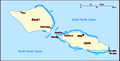
Location: Oceania, group of islands in the South Pacific Ocean, about one-half of the way from Hawaii to New Zealand
Geographic coordinates: 13 35 S, 172 20 W
Map references: Oceania
Area: Total: 2,944 sq km land: 2,934 sq km water: 10 sq km
Area - comparative: Slightly smaller than Rhode Island
Land boundaries: 0 km
Coastline: 403 km
Maritime claims: Territorial sea: 12 nm exclusive economic zone: 200 nm
Climate: Tropical; rainy season (November to April), dry season (May to October)
Terrain: Two main islands (Savaii, Upolu) and several smaller islands and uninhabited islets; narrow coastal plain with volcanic, rocky, rugged mountains in interior
Elevation extremes: Lowest point: Pacific Ocean 0 m highest point: Mauga Silisili (Savaii) 1,857 m
Natural resources: Hardwood forests, fish, hydropower
Land use: Arable land: 21.2% permanent crops: 24.38% other: 54.42% (2001)
Irrigated land: NA
Natural hazards: Occasional typhoons; active volcanism
Environment - current issues: Soil erosion, deforestation, invasive species, overfishing
Environment - international agreements: Party to: Biodiversity, Climate Change, Climate Change-Kyoto Protocol, Desertification, Hazardous Wastes, Law of the Sea, Ozone Layer Protection signed, but not ratified: none of the selected agreements
Geography - note: Occupies an almost central position within Polynesia
Advertisement
The information here has been derived from Public Domain Sources such as the CIA World Factbook. No liability can be taken for any inaccuracies.
Tot: 0.021s; Tpl: 0.007s; cc: 3; qc: 2; dbt: 0.0043s; 1; m:domysql w:travelblog (10.17.0.13); sld: 1;
; mem: 1mb
 New Zealand occupied the German protectorate of Western Samoa at the outbreak of World War I in 1914. It continued to administer the islands as a mandate and then as a trust territory until 1962, when the islands became the first Polynesian nation to...