Tanzanian Geography, Tanzania Geography
Advertisement
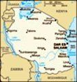
Location: Eastern Africa, bordering the Indian Ocean, between Kenya and Mozambique
Geographic coordinates: 6 00 S, 35 00 E
Map references: Africa
Area: Total: 945,087 sq km land: 886,037 sq km water: 59,050 sq km note: includes the islands of Mafia, Pemba, and Zanzibar
Area - comparative: Slightly larger than twice the size of California
Land boundaries: Total: 3,861 km border countries: Burundi 451 km, Democratic Republic of the Congo 459 km, Kenya 769 km, Malawi 475 km, Mozambique 756 km, Rwanda 217 km, Uganda 396 km, Zambia 338 km
Coastline: 1,424 km
Maritime claims: Territorial sea: 12 nm exclusive economic zone: 200 nm
Climate: Varies from tropical along coast to temperate in highlands
Terrain: Plains along coast; central plateau; highlands in north, south
Elevation extremes: Lowest point: Indian Ocean 0 m highest point: Kilimanjaro 5,895 m
Natural resources: Hydropower, tin, phosphates, iron ore, coal, diamonds, gemstones, gold, natural gas, nickel
Land use: Arable land: 4.52% permanent crops: 1.08% other: 94.4% (2001)
Irrigated land: 1,550 sq km (1998 est.)
Natural hazards: Flooding on the central plateau during the rainy season; drought
Environment - current issues: Soil degradation; deforestation; desertification; destruction of coral reefs threatens marine habitats; recent droughts affected marginal agriculture; wildlife threatened by illegal hunting and trade, especially for ivory
Environment - international agreements: Party to: Biodiversity, Climate Change, Climate Change-Kyoto Protocol, Desertification, Endangered Species, Hazardous Wastes, Law of the Sea, Ozone Layer Protection, Wetlands signed, but not ratified: none of the selected agreements
Geography - note: Kilimanjaro is highest point in Africa; bordered by three of the largest lakes on the continent: Lake Victoria (the world's second-largest freshwater lake) in the north, Lake Tanganyika (the world's second deepest) in the west, and Lake Nyasa in the southwest
Advertisement
The information here has been derived from Public Domain Sources such as the CIA World Factbook. No liability can be taken for any inaccuracies.
Tot: 0.031s; Tpl: 0.007s; cc: 3; qc: 2; dbt: 0.0038s; 1; m:domysql w:travelblog (10.17.0.13); sld: 1;
; mem: 1.1mb
 Shortly after independence, Tanganyika and Zanzibar merged to form the nation of Tanzania in 1964. One-party rule came to an end in 1995 with the first democratic elections held in the country since the 1970s. Zanzibar's semi-autonomous status and po...