Tanzanian Transportation, Tanzania Transportation
Advertisement
Railways: Total: 3,690 km narrow gauge: 969 km 1.067-m gauge; 2,721 km 1.000-m gauge (2004)
Highways: Total: 88,200 km paved: 3,704 km unpaved: 84,496 km (1999 est.)
Waterways: Lake Tanganyika, Lake Victoria, and Lake Nyasa principal avenues of commerce with neighboring countries; rivers not navigable (2004)
Pipelines: Gas 29 km; oil 866 km (2004)
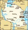
Ports and harbors: Dar es Salaam, Mtwara, Zanzibar City
Merchant marine: Total: 11 ships (1,000 GRT or over) 25,481 GRT/31,011 DWT by type: cargo 2, passenger/cargo 5, petroleum tanker 4 registered in other countries: 1 (2005)
Airports: 123 (2004 est.)
Airports - with paved runways: Total: 11 over 3,047 m: 2 2,438 to 3,047 m: 2 1,524 to 2,437 m: 5 914 to 1,523 m: 1 under 914 m: 1 (2004 est.)
Airports - with unpaved runways: Total: 112 1,524 to 2,437 m: 19 914 to 1,523 m: 60 under 914 m: 33 (2004 est.)
Heliports:
Advertisement
The information here has been derived from Public Domain Sources such as the CIA World Factbook. No liability can be taken for any inaccuracies.
Tot: 0.021s; Tpl: 0.007s; cc: 3; qc: 2; dbt: 0.0035s; 1; m:domysql w:travelblog (10.17.0.13); sld: 1;
; mem: 1.1mb
 Shortly after independence, Tanganyika and Zanzibar merged to form the nation of Tanzania in 1964. One-party rule came to an end in 1995 with the first democratic elections held in the country since the 1970s. Zanzibar's semi-autonomous status and po...