Jordanian Geography, Jordan Geography
Advertisement
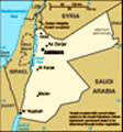
Location: Middle East, northwest of Saudi Arabia
Geographic coordinates: 31 00 N, 36 00 E
Map references: Middle East
Area: Total: 92,300 sq km land: 91,971 sq km water: 329 sq km
Area - comparative: Slightly smaller than Indiana
Land boundaries: Total: 1,635 km border countries: Iraq 181 km, Israel 238 km, Saudi Arabia 744 km, Syria 375 km, West Bank 97 km
Coastline: 26 km
Maritime claims: Territorial sea: 3 nm
Climate: Mostly arid desert; rainy season in west (November to April)
Terrain: Mostly desert plateau in east, highland area in west; Great Rift Valley separates East and West Banks of the Jordan River
Elevation extremes: Lowest point: Dead Sea -408 m highest point: Jabal Ram 1,734 m
Natural resources: Phosphates, potash, shale oil
Land use: Arable land: 2.67% permanent crops: 1.83% other: 95.5% (2001)
Irrigated land: 750 sq km (1998 est.)
Natural hazards: Droughts; periodic earthquakes
Environment - current issues: Limited natural fresh water resources; deforestation; overgrazing; soil erosion; desertification
Environment - international agreements: Party to: Biodiversity, Climate Change, Climate Change-Kyoto Protocol, Desertification, Endangered Species, Hazardous Wastes, Law of the Sea, Marine Dumping, Ozone Layer Protection, Wetlands signed, but not ratified: none of the selected agreements
Geography - note: Strategic location at the head of the Gulf of Aqaba and as the Arab country that shares the longest border with Israel and the occupied West Bank
Advertisement
The information here has been derived from Public Domain Sources such as the CIA World Factbook. No liability can be taken for any inaccuracies.
Tot: 0.092s; Tpl: 0.012s; cc: 6; qc: 6; dbt: 0.0179s; 1; m:domysql w:travelblog (10.17.0.13); sld: 1;
; mem: 1.1mb
 For most of its history since independence from British administration in 1946, Jordan was ruled by King HUSSEIN (1953-99). A pragmatic ruler, he successfully navigated competing pressures from the major powers (US, USSR, and UK), various Arab states...