Djiboutian Geography, Djibouti Geography
Advertisement
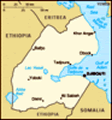
Location: Eastern Africa, bordering the Gulf of Aden and the Red Sea, between Eritrea and Somalia
Geographic coordinates: 11 30 N, 43 00 E
Map references: Africa
Area: Total: 23,000 sq km land: 22,980 sq km water: 20 sq km
Area - comparative: Slightly smaller than Massachusetts
Land boundaries: Total: 516 km border countries: Eritrea 109 km, Ethiopia 349 km, Somalia 58 km
Coastline: 314 km
Maritime claims: Territorial sea: 12 nm contiguous zone: 24 nm exclusive economic zone: 200 nm
Climate: Desert; torrid, dry
Terrain: Coastal plain and plateau separated by central mountains
Elevation extremes: Lowest point: Lac Assal -155 m highest point: Moussa Ali 2,028 m
Natural resources: Geothermal areas, gold, clay, granite, limestone, marble, salt, diatomite, gypsum, pumice, petroleum
Land use: Arable land: 0.04% permanent crops: 0% other: 99.96% (2001)
Irrigated land: 10 sq km (1998 est.)
Natural hazards: Earthquakes; droughts; occasional cyclonic disturbances from the Indian Ocean bring heavy rains and flash floods
Environment - current issues: Inadequate supplies of potable water; limited arable land; desertification; endangered species
Environment - international agreements: Party to: Biodiversity, Climate Change, Climate Change-Kyoto Protocol, Desertification, Endangered Species, Hazardous Wastes, Law of the Sea, Ozone Layer Protection, Ship Pollution signed, but not ratified: none of the selected agreements
Geography - note: Strategic location near world's busiest shipping lanes and close to Arabian oilfields; terminus of rail traffic into Ethiopia; mostly wasteland; Lac Assal (Lake Assal) is the lowest point in Africa
Advertisement
The information here has been derived from Public Domain Sources such as the CIA World Factbook. No liability can be taken for any inaccuracies.
Tot: 0.042s; Tpl: 0.007s; cc: 5; qc: 8; dbt: 0.0165s; 1; m:domysql w:travelblog (10.17.0.13); sld: 1;
; mem: 1.1mb
 The French Territory of the Afars and the Issas became Djibouti in 1977. Hassan Gouled APTIDON installed an authoritarian one-party state and proceeded to serve as president until 1999. Unrest among the Afars minority during the 1990s led to a civil ...