Bruneian Geography, Brunei Geography
Advertisement
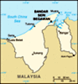
Location: Southeastern Asia, bordering the South China Sea and Malaysia
Geographic coordinates: 4 30 N, 114 40 E
Map references: Southeast Asia
Area: Total: 5,770 sq km land: 5,270 sq km water: 500 sq km
Area - comparative: Slightly smaller than Delaware
Land boundaries: Total: 381 km border countries: Malaysia 381 km
Coastline: 161 km
Maritime claims: Territorial sea: 12 nm exclusive economic zone: 200 nm or to median line
Climate: Tropical; hot, humid, rainy
Terrain: Flat coastal plain rises to mountains in east; hilly lowland in west
Elevation extremes: Lowest point: South China Sea 0 m highest point: Bukit Pagon 1,850 m
Natural resources: Petroleum, natural gas, timber
Land use: Arable land: 0.57% permanent crops: 0.76% other: 98.67% (2001)
Irrigated land: 10 sq km (1998 est.)
Natural hazards: Typhoons, earthquakes, and severe flooding are rare
Environment - current issues: Seasonal smoke/haze resulting from forest fires in Indonesia
Environment - international agreements: Party to: Endangered Species, Hazardous Wastes, Law of the Sea, Ozone Layer Protection, Ship Pollution signed, but not ratified: none of the selected agreements
Geography - note: Close to vital sea lanes through South China Sea linking Indian and Pacific Oceans; two parts physically separated by Malaysia; almost an enclave of Malaysia
Advertisement
The information here has been derived from Public Domain Sources such as the CIA World Factbook. No liability can be taken for any inaccuracies.
Tot: 0.041s; Tpl: 0.008s; cc: 5; qc: 8; dbt: 0.0141s; 1; m:domysql w:travelblog (10.17.0.13); sld: 1;
; mem: 1.1mb
 The Sultanate of Brunei's influence peaked between the 15th and 17th centuries when its control extended over coastal areas of northwest Borneo and the southern Philippines. Brunei subsequently entered a period of decline brought on by internal strif...