Bhutanese Geography, Bhutan Geography
Advertisement
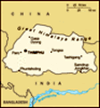
Location: Southern Asia, between China and India
Geographic coordinates: 27 30 N, 90 30 E
Map references: Asia
Area: Total: 47,000 sq km land: 47,000 sq km water: 0 sq km
Area - comparative: About half the size of Indiana
Land boundaries: Total: 1,075 km border countries: China 470 km, India 605 km
Coastline: 0 km (landlocked)
Maritime claims: None (landlocked)
Climate: Varies; tropical in southern plains; cool winters and hot summers in central valleys; severe winters and cool summers in Himalayas
Terrain: Mostly mountainous with some fertile valleys and savanna
Elevation extremes: Lowest point: Drangme Chhu 97 m highest point: Kula Kangri 7,553 m
Natural resources: Timber, hydropower, gypsum, calcium carbonate
Land use: Arable land: 3.09% permanent crops: 0.43% other: 96.48% (2001)
Irrigated land: 400 sq km (1998 est.)
Natural hazards: Violent storms from the Himalayas are the source of the country's name which translates as Land of the Thunder Dragon; frequent landslides during the rainy season
Environment - current issues: Soil erosion; limited access to potable water
Environment - international agreements: Party to: Biodiversity, Climate Change, Climate Change-Kyoto Protocol, Endangered Species, Hazardous Wastes signed, but not ratified: Law of the Sea
Geography - note: Landlocked; strategic location between China and India; controls several key Himalayan mountain passes
Advertisement
The information here has been derived from Public Domain Sources such as the CIA World Factbook. No liability can be taken for any inaccuracies.
Tot: 0.018s; Tpl: 0.007s; cc: 3; qc: 2; dbt: 0.0024s; 1; m:domysql w:travelblog (10.17.0.13); sld: 1;
; mem: 1.1mb
 In 1865, Britain and Bhutan signed the Treaty of Sinchulu, under which Bhutan would receive an annual subsidy in exchange for ceding some border land. Under British influence, a monarchy was set up in 1907; three years later, a treaty was signed wher...