Burmese Geography, Burma Geography
Advertisement
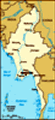
Location: Southeastern Asia, bordering the Andaman Sea and the Bay of Bengal, between Bangladesh and Thailand
Geographic coordinates: 22 00 N, 98 00 E
Map references: Southeast Asia
Area: Total: 678,500 sq km land: 657,740 sq km water: 20,760 sq km
Area - comparative: Slightly smaller than Texas
Land boundaries: Total: 5,876 km border countries: Bangladesh 193 km, China 2,185 km, India 1,463 km, Laos 235 km, Thailand 1,800 km
Coastline: 1,930 km
Maritime claims: Territorial sea: 12 nm contiguous zone: 24 nm exclusive economic zone: 200 nm continental shelf: 200 nm or to the edge of the continental margin
Climate: Tropical monsoon; cloudy, rainy, hot, humid summers (southwest monsoon, June to September); less cloudy, scant rainfall, mild temperatures, lower humidity during winter (northeast monsoon, December to April)
Terrain: Central lowlands ringed by steep, rugged highlands
Elevation extremes: Lowest point: Andaman Sea 0 m highest point: Hkakabo Razi 5,881 m
Natural resources: Petroleum, timber, tin, antimony, zinc, copper, tungsten, lead, coal, some marble, limestone, precious stones, natural gas, hydropower
Land use: Arable land: 15.19% permanent crops: 0.97% other: 83.84% (2001)
Irrigated land: 15,920 sq km (1998 est.)
Natural hazards: Destructive earthquakes and cyclones; flooding and landslides common during rainy season (June to September); periodic droughts
Environment - current issues: Deforestation; industrial pollution of air, soil, and water; inadequate sanitation and water treatment contribute to disease
Environment - international agreements: Party to: Biodiversity, Climate Change, Climate Change-Kyoto Protocol, Desertification, Endangered Species, Law of the Sea, Ozone Layer Protection, Ship Pollution, Tropical Timber 83, Tropical Timber 94 signed, but not ratified: none of the selected agreements
Geography - note: Strategic location near major Indian Ocean shipping lanes
Advertisement
The information here has been derived from Public Domain Sources such as the CIA World Factbook. No liability can be taken for any inaccuracies.
Tot: 0.02s; Tpl: 0.007s; cc: 3; qc: 2; dbt: 0.0027s; 1; m:domysql w:travelblog (10.17.0.13); sld: 1;
; mem: 1.1mb
 Britain conquered Burma over a period of 62 years (1824-1886) and incorporated it into its Indian Empire. Burma was administered as a province of India until 1937 when it became a separate, self-governing colony; independence from the Commonwealth wa...