Burmese Government, Burma Government
Advertisement
Country name: Conventional long form: Union of Burma conventional short form: Burma local long form: Pyidaungzu Myanma Naingngandaw (translated by the US Government as Union of Myanma and by the Burmese as Union of Myanmar) local short form: Myanma Naingngandaw former: Socialist Republic of the Union of Burma note: since 1989 the military authorities in Burma have promoted the name Myanmar as a conventional name for their state; this decision was not approved by any sitting legislature in Burma, and the US Government did not adopt the name, which is a derivative of the Burmese short-form name Myanma Naingngandaw
Government type: Military junta
Capital: Rangoon (government refers to the capital as Yangon)
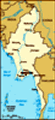
Administrative divisions: 7 divisions (taing-myar, singular - taing) and 7 states (pyi ne-myar, singular - pyi ne) : divisions: Ayeyarwady, Bago, Magway, Mandalay, Sagaing, Tanintharyi, Yangon : states: Chin State, Kachin State, Kayin State, Kayah State, Mon State, Rakhine State, Shan State
Independence: 4 January 1948 (from UK)
National holiday: Independence Day, 4 January (1948); Union Day, 12 February (1947)
Constitution: 3 January 1974; suspended since 18 September 1988; national convention convened in 1993 to draft a new constitution but collapsed in 1996; reconvened in 2004 but does not include participation of democratic opposition
Legal system: Has not accepted compulsory ICJ jurisdiction
Suffrage: 18 years of age; universal
Executive branch: Chief of state: Chairman of the State Peace and Development Council Sr. Gen. THAN SHWE (since 23 April 1992) head of government: Prime Minister, Gen SOE WIN (since 19 October 2004) cabinet: State Peace and Development Council (SPDC); military junta, so named 15 November 1997, which initially assumed power 18 September 1988 under the name State Law and Order Restoration Council (SLORC); the SPDC oversees the cabinet elections: none
Legislative branch: Unicameral People's Assembly or Pyithu Hluttaw (485 seats; members elected by popular vote to serve four-year terms) elections: last held 27 May 1990, but Assembly never allowed by junta to convene election results: percent of vote by party - NA%; seats by party - NLD 392 (opposition), SNLD 23 (opposition), NUP 10 (pro-government), other 60
Judicial branch: Remnants of the British-era legal system are in place, but there is no guarantee of a fair public trial; the judiciary is not independent of the executive
Political parties and leaders: National League for Democracy or NLD [AUNG SHWE, chairman, AUNG SAN SUU KYI, general secretary]; National Unity Party or NUP (pro-government) [THA KYAW]; Shan Nationalities League for Democracy or SNLD [KHUN HTUN OO]; and other smaller parties
Political pressure groups and leaders: National Coalition Government of the Union of Burma or NCGUB (self-proclaimed government in exile) ["Prime Minister" Dr. SEIN WIN] consists of individuals, some legitimately elected to the People's Assembly in 1990 (the group fled to a border area and joined insurgents in December 1990 to form parallel government in exile); Kachin Independence Army or KIA; Karen National Union or KNU; several Shan factions; United Wa State Army or UWSA; Union Solidarity and Development Association or USDA (pro-government, a social and political organization) [THAN AUNG, general secretary]
International organization participation: APT, ARF, AsDB, ASEAN, CP, FAO, G-77, IAEA, IBRD, ICAO, ICRM, IDA, IFAD, IFC, IFRCS, IHO, ILO, IMF, IMO, Interpol, IOC, ITU, NAM, OPCW (signatory), UN, UNCTAD, UNESCO, UNIDO, UPU, WCO, WHO, WIPO, WMO, WTO
Diplomatic representation in the US: Chief of mission: vacant chancery: 2300 S Street NW, Washington, DC 20008 telephone: [1] (202) 332-9044 FAX: [1] (202) 332-9046 consulate(s) general: New York
Diplomatic representation from the US: Chief of mission: Charge d'Affaires Carmen M. MARTINEZ embassy: 581 Merchant Street, Rangoon (GPO 521) mailing address: Box B, APO AP 96546 telephone: [95] (1) 379 880, 379 881 FAX: [95] (1) 256 018
Flag description: Red with a blue rectangle in the upper hoist-side corner bearing, 14 white five-pointed stars encircling a cogwheel containing a stalk of rice; the 14 stars represent the 7 administrative divisions and 7 states
Advertisement
The information here has been derived from Public Domain Sources such as the CIA World Factbook. No liability can be taken for any inaccuracies.
Tot: 0.038s; Tpl: 0.009s; cc: 3; qc: 2; dbt: 0.0047s; 1; m:domysql w:travelblog (10.17.0.13); sld: 1;
; mem: 1.1mb
 Britain conquered Burma over a period of 62 years (1824-1886) and incorporated it into its Indian Empire. Burma was administered as a province of India until 1937 when it became a separate, self-governing colony; independence from the Commonwealth wa...