French Guianese Geography, French Guiana Geography
Advertisement
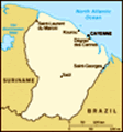
Location: Northern South America, bordering the North Atlantic Ocean, between Brazil and Suriname
Geographic coordinates: 4 00 N, 53 00 W
Map references: South America
Area: Total: 91,000 sq km land: 89,150 sq km water: 1,850 sq km
Area - comparative: Slightly smaller than Indiana
Land boundaries: Total: 1,183 km border countries: Brazil 673 km, Suriname 510 km
Coastline: 378 km
Maritime claims: Territorial sea: 12 nm exclusive economic zone: 200 nm
Climate: Tropical; hot, humid; little seasonal temperature variation
Terrain: Low-lying coastal plains rising to hills and small mountains
Elevation extremes: Lowest point: Atlantic Ocean 0 m highest point: Bellevue de l'Inini 851 m
Natural resources: Bauxite, timber, gold (widely scattered), petroleum, kaolin, fish, niobium, tantalum, clay
Land use: Arable land: 0.14% permanent crops: 0.05% other: 99.81% (90% forest, 10% other) (2001)
Irrigated land: 20 sq km (1998 est.)
Natural hazards: High frequency of heavy showers and severe thunderstorms; flooding
Environment - current issues: NA
Environment - international agreements:
Geography - note: Mostly an unsettled wilderness; the only non-independent portion of the South American continent
Advertisement
The information here has been derived from Public Domain Sources such as the CIA World Factbook. No liability can be taken for any inaccuracies.
Tot: 0.022s; Tpl: 0.008s; cc: 3; qc: 2; dbt: 0.0031s; 1; m:domysql w:travelblog (10.17.0.13); sld: 1;
; mem: 1mb
 First settled by the French in 1604, French Guiana was the site of notorious penal settlements until 1951. The European Space Agency launches its communication satellites from Kourou....