Guamanian Geography, Guam Geography
Advertisement
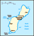
Location: Oceania, island in the North Pacific Ocean, about three-quarters of the way from Hawaii to the Philippines
Geographic coordinates: 13 28 N, 144 47 E
Map references: Oceania
Area: Total: 549 sq km land: 549 sq km water: 0 sq km
Area - comparative: Three times the size of Washington, DC
Land boundaries: 0 km
Coastline: 125.5 km
Maritime claims: Territorial sea: 12 nm exclusive economic zone: 200 nm
Climate: Tropical marine; generally warm and humid, moderated by northeast trade winds; dry season from January to June, rainy season from July to December; little seasonal temperature variation
Terrain: Volcanic origin, surrounded by coral reefs; relatively flat coralline limestone plateau (source of most fresh water), with steep coastal cliffs and narrow coastal plains in north, low hills in center, mountains in south
Elevation extremes: Lowest point: Pacific Ocean 0 m highest point: Mount Lamlam 406 m
Natural resources: Fishing (largely undeveloped), tourism (especially from Japan)
Land use: Arable land: 9.09% permanent crops: 16.36% other: 74.55% (2001)
Irrigated land: NA
Natural hazards: Frequent squalls during rainy season; relatively rare, but potentially very destructive typhoons (June - December)
Environment - current issues: Extirpation of native bird population by the rapid proliferation of the brown tree snake, an exotic, invasive species
Environment - international agreements:
Geography - note: Largest and southernmost island in the Mariana Islands archipelago; strategic location in western North Pacific Ocean
Advertisement
The information here has been derived from Public Domain Sources such as the CIA World Factbook. No liability can be taken for any inaccuracies.
Tot: 0.034s; Tpl: 0.007s; cc: 3; qc: 10; dbt: 0.0108s; 1; m:domysql w:travelblog (10.17.0.13); sld: 1;
; mem: 1mb
 Guam was ceded to the US by Spain in 1898. Captured by the Japanese in 1941, it was retaken by the US three years later. The military installation on the island is one of the most strategically important US bases in the Pacific....