Advertisement
Published: February 10th 2013
More photos at:
Picasa
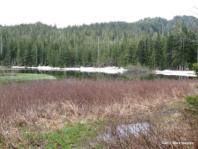
I started my morning with the hike up to Mink Lake. For the most part is was a simple (if steep) hike. It sounded like there were some nice rapids along the creek leaving Mink Lake, but the trail never came close enough to get a good picture. I started seeing patchy snow around 3000 feet, but there was only one small patch of snow was on the trail. There was a fair bit of snow around the edges of Mink Lake though. From there I hiked back down and started off toward Hurricane Ridge.

Between Sol Duc and Hurricane Ridge, US-101 runs along the edge of Lake Crescent, an impressively large and deep (officially it is 624 feet deep (the limit of the instruments used in the official survey), but other surveys make claims of points in excess of 1000 feet deep (also the limit of the instruments used in those surveys)) glacier carved lake near the northern edge of Olympic NP. The waters are bright blue and exceptionally clear. The pictures I took this day don't do the water color justice. It was mostly overcast, so the picutres tend to make the water look grey, not blue.
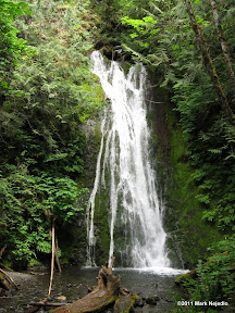
Also between Sol Duc and Hurricane Ridge is the Elwha River Valley. Normally another easily accessible area of the park, the road up this valley was closed while I was there to repair landslide damage (The repairs were completed and road up the valley opened just a couple days after I left the area). There was, however, a falls marked on the map (Madison Falls) just inside the park border that I thought might be accessible, so I took a short side trip up the Elwha road to see. There are also two dams along the Elwha, scheduled for removal starting in September 2011, which I didn't expect to be able to see due to the road closure. I was able to reach Madison Falls, and I also had a long, interesting conversation with a park ranger who happened to be in the parking lot for Madison Falls. Among other things, she told me that the road was open for hiking to the upper (Glines Canyon) dam (a seven mile round trip, which I regret passing on), that the Lower Elwha dam could be reached by road, and they were allowing people to walk across it. So, after visiting the falls I took another side trip to see the lower dam. The Lower Elwha dam was pretty impressive, especially with the flood gates fully open to draw down the reservoir (power generation ended June 1).
After the dam, I headed to Hurricane Ridge. Besides being a narrow, steep, and winding road, there was also one of the densest fogs I've driven in on the road. I did get to hear one of the rangers give an interesting talk on the animals in the park, spending quite a bit of time on the Olympic Marmoset. The marmoset population has declined significantly in recent years (though showing signs of stabilizing), due largely to the efforts of the non-native coyote (historically, the Olympic Peninsula had wolves, but not coyotes. After the wolves were killed off, coyotes moved in). When I was done at the visitor's center, I headed back down the mountain to the (much less foggy) campground for the night.
Advertisement
Tot: 0.13s; Tpl: 0.009s; cc: 5; qc: 45; dbt: 0.0423s; 1; m:domysql w:travelblog (10.17.0.13); sld: 1;
; mem: 1.2mb


