Bermudian Geography, Bermuda Geography
Advertisement
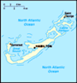
Location: North America, group of islands in the North Atlantic Ocean, east of South Carolina (US)
Geographic coordinates: 32 20 N, 64 45 W
Map references: North America
Area: Total: 53.3 sq km land: 53.3 sq km water: 0 sq km
Area - comparative: About one-third the size of Washington, DC
Land boundaries: 0 km
Coastline: 103 km
Maritime claims: Territorial sea: 12 nm exclusive fishing zone: 200 nm
Climate: Subtropical; mild, humid; gales, strong winds common in winter
Terrain: Low hills separated by fertile depressions
Elevation extremes: Lowest point: Atlantic Ocean 0 m highest point: Town Hill 76 m
Natural resources: Limestone, pleasant climate fostering tourism
Land use: Arable land: 20% permanent crops: 0% other: 80% (55% developed, 45% rural/open space) (2001)
Irrigated land: NA
Natural hazards: Hurricanes (June to November)
Environment - current issues: Asbestos disposal; water pollution; preservation of open space; sustainable development
Environment - international agreements:
Geography - note: Consists of about 138 coral islands and islets with ample rainfall, but no rivers or freshwater lakes; some land was leased by US Government from 1941 to 1995
Advertisement
The information here has been derived from Public Domain Sources such as the CIA World Factbook. No liability can be taken for any inaccuracies.
Tot: 0.039s; Tpl: 0.008s; cc: 3; qc: 10; dbt: 0.0139s; 1; m:domysql w:travelblog (10.17.0.13); sld: 1;
; mem: 1mb
 Bermuda was first settled in 1609 by shipwrecked English colonists headed for Virginia. Tourism to the island to escape North American winters first developed in Victorian times. Tourism continues to be important to the island's economy, although int...