Syrian Geography, Syria Geography
Advertisement
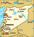
Location: Middle East, bordering the Mediterranean Sea, between Lebanon and Turkey
Geographic coordinates: 35 00 N, 38 00 E
Map references: Middle East
Area: Total: 185,180 sq km land: 184,050 sq km water: 1,130 sq km note: includes 1,295 sq km of Israeli-occupied territory
Area - comparative: Slightly larger than North Dakota
Land boundaries: Total: 2,253 km border countries: Iraq 605 km, Israel 76 km, Jordan 375 km, Lebanon 375 km, Turkey 822 km
Coastline: 193 km
Maritime claims: Territorial sea: 12 nm contiguous zone: 41 nm
Climate: Mostly desert; hot, dry, sunny summers (June to August) and mild, rainy winters (December to February) along coast; cold weather with snow or sleet periodically in Damascus
Terrain: Primarily semiarid and desert plateau; narrow coastal plain; mountains in west
Elevation extremes: Lowest point: unnamed location near Lake Tiberias -200 m highest point: Mount Hermon 2,814 m
Natural resources: Petroleum, phosphates, chrome and manganese ores, asphalt, iron ore, rock salt, marble, gypsum, hydropower
Land use: Arable land: 25.22% permanent crops: 4.43% other: 70.35% (2001)
Irrigated land: 12,130 sq km (1998 est.)
Natural hazards: Dust storms, sandstorms
Environment - current issues: Deforestation; overgrazing; soil erosion; desertification; water pollution from raw sewage and petroleum refining wastes; inadequate potable water
Environment - international agreements: Party to: Biodiversity, Climate Change, Desertification, Endangered Species, Hazardous Wastes, Ozone Layer Protection, Ship Pollution, Wetlands signed, but not ratified: Environmental Modification
Geography - note: There are 42 Israeli settlements and civilian land use sites in the Israeli-occupied Golan Heights (February 2002 est.)
Advertisement
The information here has been derived from Public Domain Sources such as the CIA World Factbook. No liability can be taken for any inaccuracies.
Tot: 0.047s; Tpl: 0.008s; cc: 6; qc: 6; dbt: 0.0059s; 1; m:domysql w:travelblog (10.17.0.13); sld: 1;
; mem: 1.1mb
 Following the breakup of the Ottoman Empire during World War I, Syria was administered by the French until independence in 1946. In the 1967 Arab-Israeli War, Syria lost the Golan Heights to Israel. Syrian troops - stationed in Lebanon since 1976 in ...