Qatari Geography, Qatar Geography
Advertisement
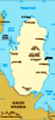
Location: Middle East, peninsula bordering the Persian Gulf and Saudi Arabia
Geographic coordinates: 25 30 N, 51 15 E
Map references: Middle East
Area: Total: 11,437 sq km land: 11,437 sq km water: 0 sq km
Area - comparative: Slightly smaller than Connecticut
Land boundaries: Total: 60 km border countries: Saudi Arabia 60 km
Coastline: 563 km
Maritime claims: Territorial sea: 12 nm contiguous zone: 24 nm exclusive economic zone: as determined by bilateral agreements or the median line
Climate: Arid; mild, pleasant winters; very hot, humid summers
Terrain: Mostly flat and barren desert covered with loose sand and gravel
Elevation extremes: Lowest point: Persian Gulf 0 m highest point: Qurayn Abu al Bawl 103 m
Natural resources: Petroleum, natural gas, fish
Land use: Arable land: 1.64% permanent crops: 0.27% other: 98.09% (2001)
Irrigated land: 130 sq km (1998 est.)
Natural hazards: Haze, dust storms, sandstorms common
Environment - current issues: Limited natural fresh water resources are increasing dependence on large-scale desalination facilities
Environment - international agreements: Party to: Biodiversity, Climate Change, Climate Change-Kyoto Protocol, Desertification, Endangered Species, Hazardous Wastes, Law of the Sea, Ozone Layer Protection signed, but not ratified: none of the selected agreements
Geography - note: Strategic location in central Persian Gulf near major petroleum deposits
Advertisement
The information here has been derived from Public Domain Sources such as the CIA World Factbook. No liability can be taken for any inaccuracies.
Tot: 0.031s; Tpl: 0.007s; cc: 5; qc: 6; dbt: 0.0054s; 1; m:domysql w:travelblog (10.17.0.13); sld: 1;
; mem: 1.1mb
 Ruled by the Al Thani family since the mid-1800s, Qatar transformed itself from a poor British protectorate noted mainly for pearling into an independent state with significant oil and natural gas revenues. During the late 1980s and early 1990s, the ...