Kuwaiti Geography, Kuwait Geography
Advertisement
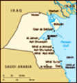
Location: Middle East, bordering the Persian Gulf, between Iraq and Saudi Arabia
Geographic coordinates: 29 30 N, 45 45 E
Map references: Middle East
Area: Total: 17,820 sq km land: 17,820 sq km water: 0 sq km
Area - comparative: Slightly smaller than New Jersey
Land boundaries: Total: 462 km border countries: Iraq 240 km, Saudi Arabia 222 km
Coastline: 499 km
Maritime claims: Territorial sea: 12 nm
Climate: Dry desert; intensely hot summers; short, cool winters
Terrain: Flat to slightly undulating desert plain
Elevation extremes: Lowest point: Persian Gulf 0 m highest point: unnamed location 306 m
Natural resources: Petroleum, fish, shrimp, natural gas
Land use: Arable land: 0.73% permanent crops: 0.11% other: 99.16% (2001)
Irrigated land: 60 sq km (1998 est.)
Natural hazards: Sudden cloudbursts are common from October to April and bring heavy rain, which can damage roads and houses; sandstorms and dust storms occur throughout the year, but are most common between March and August
Environment - current issues: Limited natural fresh water resources; some of world's largest and most sophisticated desalination facilities provide much of the water; air and water pollution; desertification
Environment - international agreements: Party to: Biodiversity, Climate Change, Desertification, Endangered Species, Environmental Modification, Hazardous Wastes, Law of the Sea, Ozone Layer Protection signed, but not ratified: Marine Dumping
Geography - note: Strategic location at head of Persian Gulf
Advertisement
The information here has been derived from Public Domain Sources such as the CIA World Factbook. No liability can be taken for any inaccuracies.
Tot: 0.041s; Tpl: 0.007s; cc: 3; qc: 10; dbt: 0.0109s; 1; m:domysql w:travelblog (10.17.0.13); sld: 1;
; mem: 1.1mb
 Britain oversaw foreign relations and defense for the ruling Kuwaiti AL-SABAH dynasty from 1899 until independence in 1961. Kuwait was attacked and overrun by Iraq on 2 August 1990. Following several weeks of aerial bombardment, a US-led, UN coalitio...